
Archived Articles
Confirmation Of Subsurface Sulfur Waters
At North Bimini, Bahamas, As Predicted
In Edgar Cayce Reading 996-12
At North Bimini, Bahamas, As Predicted
In Edgar Cayce Reading 996-12
BACKGROUND
This article is part of THC's continuing effort to assess the truth of Earth science information found in the readings of Edgar Cayce, the “sleeping prophet” of Virginia Beach. Previous relevant research that we have done on Bimini may be found in articles on this web site and in chapters 28 and 29 of our book.
Cayce reading 996-12 was given on March 2, 1927, in Miami's Halcyon Hotel. It is fascinating for a number of reasons, not the least of which it has to do with plans offered by Cayce's source, or sources, for the reading. These plans describe a premier resort could be developed on the Bimini Islands. A program for such a development was outlined for two gentlemen, A. C. Preston, and Thomas J. Peters. (Peters was present only part of the time for the reading). In addition to these two, only Gladys Davis and Gertrude Cayce (conductor of the reading) were present in the hotel room with Mr. Cayce.
We think that broad aspects of the resort plan given via Cayce, the psychic channeler, may have been sourced by him from the mind of A.C. Preston. But various details given, such as natural power sources that could be used to electrify the resort complex, or details on how deep to drill for potable water or for healing black sulfur waters, could only have come from sources beyond the three-dimensional environment in which we dwell.
We enter reading 996-12 at the following point, where Preston (or Peters) asks the following questions of sleeping Cayce.
(Q) How deep will we have to drill {on South Bimini} for the fresh water?
(A) Eight hundred and ninety-two (892) feet.
(Q) What supply would that obtain?
(A) One thousand eight hundred gallons (1,800) per hour. The electro-hydro power would be made from that condition as may be builded, as given, which would supply all of the power necessary for any project that might be - might be - even undertaken here; for this would become not only a strategic point in the affairs of this - THIS - continent, but of others - as it has been in the eons past.
(Q) Could an additional supply of water be obtained by going deeper?
(A) This is the strata for the water. Other supplies may be obtained in various portions near here, which would only increase the amount if necessary. This supply would increase, see?
(Q) Would this be Artesian?
(A) Artesian.
(Q) It would flow out of the top?
(A) Flow out over the top.
(Q) Is there any sulphur in this water?
(A) Sulphur may be obtained here. THIS is sweet water here.
(Q) Give the chemical analysis.
(A) Fifty-six percent (56%) pure water. Silicon a trace. Lime a trace. Magnesia a trace. This would be pure sweet water here, you see, with only the traces of those of silicon, magnesia, of lime, and of other properties as only would be seen in traces of same, see? and in the changes as brought, as given, this may be only increased by the heating, or the various conditions as may be brought to same - for, as a health resort, as the building up of the general body, and as of the whole system, see?
The sulphur waters may be obtained where there is seen an old channel on north end of the south portion of north island. These, we find, will be of the black sulphur, yet for certain conditions - and for the baths as may be instituted through same - will be quite beneficial to health, and especially to those of the neuritic conditions - nervousness, and of the germ of rheumatic conditions, see? This will be found only eighty-nine to ninety (89 to 90) feet deep, see?
Jonathan Eagle, Alfredo Salas, and I were able to confirm the words highlighted in yellowjust above, last February on a trip to south Florida to meet with water-well drillers and resort developers who have been working on North Bimini.
Now this may sound unnecessarily contrived, but we want to protect the reputations of those individuals who might possibly be embarrassed, or even professionally impacted, by having their names associated with Cayce's readings. And so, we are not going to reveal their names, or the names of their companies. We can assure you, however, that we have copies of the logs of the test wells drilled on North Bimini, relevant portions of which are produced without alteration below.
LOCATIONS AND LOGS FOR TWO TEST WELLS
Figures 1 and 2 show the locations, relative to the “old channel on north end of the south portion of north island” of the two test wells drilled within the past five years on North Bimini.
|
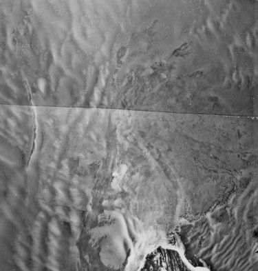
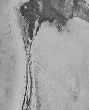
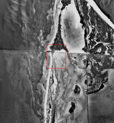
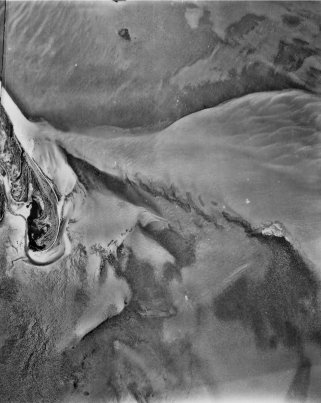
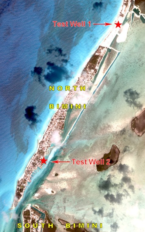 Fig. 2. Approximate locations of Test Well 1, a 200-ft-deep well, and Test Well 2, a 400-ft-deep well.
 In terms of Cayce's reading extract above, we are primarily interested in the log of Test Well 1. The log of Test Well 2 will provide supporting information to the statements found in the reading as to the black color of the sulfur water found there. Both wells were exploratory (“test') wells drilled for prospective desalinization plants on Bimini, and both well logs were prepared by a Ph. D. candidate in geology.
Relevant Portions Of Log of
Test Well 1
Here is the unedited log prepared by the student. (Only one sentence, on the conductivity of water in each well, was left out.) Hutton's comments on some of the geologic terms are placed in curly brackets. Words in bold font are done so for emphasis by Hutton.
The lithologic core was predictably unconsolidated sediment for the first 20 ft and then lithified calcium carbonate for the rest of the core. The core below 20 ft was mostly wackestone, packstone, and grainstone with some instances of rudstone.
{Wackestone is a mud supported carbonate sedimentary rock containing more than 10 % grains; packstone is sedimentary carbonate rock whose granular material is arranged in a self-supporting framework, yet also contains some matrix of calcareous mud; grainstone is essentially mud-free carbonate material; and rudstone is a carbonate rock composed of bioclasts of other fragments, over 2 mm in diameter, closely packed, in physical contact; the interstices may be open, or filled with fine carbonate sediment or crystalline cement.}
A number of subaerial exposures {of the carbonate sediments in the well core} were noted, indicating sea level regressions and transgressions. These exposures were marked by small solution cavities, darker staining of the rock and in some cases iron coloring and black pebbles. Coral became evident at 70 ft and continued down core. At 130 ft, Stylophora sp was identified, indicating that a date during the Pliocene had been reached. (Stylophora sp became extinct after the Pliocene.) The first 70 ft was very permeable and the water, distinctly clearer. Hydrogen sulfide was encountered at 90 ft-100 ft, and was present downcore.
Here we have confirmation of the passage in Cayce reading 996-12 that states that sulfur water will be “found only eighty-nine to ninety (89 to 90) feet deep.” But what about black sulfur water? Continue reading below.
Relevant Portions Of Log of Test Well 2
The second well, to be used privately by the Big Game Club, was drilled to 400 ft. The lithology was very similar to the first well, being wackestone, packstone and grainstone. Subareal exposures were noted again and these correlated with the core of the first site reasonably well. Stylophora sp was encountered at 130 ft. Smaller coral pieces were encountered compared to the first well. This is to be expected, however, as coral usually grows patchily and not in a uniform manner. Below 200 ft the lithology was fairly similar, with considerable burrowing. Hydrogen sulfide was reached at approximately 120 ft. The difference between the two wells may be linked to slight changes in the water table, but it is most likely due to the topography of the island.
Under the heading of “Notes,” on a page that accompanies the well log for Test Well 2, one finds:
120 ft H2S = 5.0
130 ft H2S = 5.0
140 ft H2S = 5.0, black water
400 ft artesian water pressure (H20 comes up in pipe on its own)
Here, then, we have confirmation of black sulfur water, at 140 feet in Well 2. And the information about artesian water pressure suggests that the strange statement about potential flow of sweet water over the top of any well pipe for a potable water-well drilled on South Bimini may turn out to be true, as unlikely as it might seem for these two oceanic islands of Bimini.
As we wrote in our book, on page 308,
For 1,800 gallons per hr of water to “flow out over the top” of the hypothetical well would require flow to originate on a higher, larger island and then to flow, via a well, to the less elevated surface of South Bimini. Artesian flow at Bimini would thus occur by classical U-tube type of flow in which the higher arm of the “tube” is the end on the higher island. Our conjecture is that only Andros Island, to the southeast of Bimini and the largest island in the Bahamas but still on the Great Bahama Bank, would qualify.
The groundwater recharge area would presumably be northern Andros Island, which lies about 80 to 110 miles from South Bimini. If this seems a reasonable conjecture, then for the fresh water to remain uncontaminated by salt water and to keep the water under sufficient confinement to allow for artesian flow when tapped by drilling at South Bimini, the water would have to flow in a stratum of limestone sealed both top and bottom.
This last requirement may be asking a bit too much of the groundwater environment of the Great Bahama Bank, because seawater circulation was encountered in the Great Isaac Island wildcat well in most of the upper 6,500 ft drilled. Below that depth, both sealed conditions and structural closure were encountered. Anhydrite layers present in that part of the geologic section, similar to those in southern Florida, appear to form effective seals.
As to the origin of the black sulfur water, J. Kargel alerted Hutton to a 1999 paper of his on volcanogenic sulfur (Icarus, v. 142, p. 249). The focus was on the Yellowstone volcano where one of the samples he analyzed chemically and spectroscopically was from the “Cinder Pool,” a gray, turbid acidic pool with a molten sulfur pool at the bottom (20 m deep) and black spherules that float to the top. Hutton has speculated that the “many varied minerals” mentioned elsewhere in reading 996-12, as being present just below the surface in the vicinity of the Bimini Inlet, might be a mineralized zone associated with a buried volcano peak, or a volcanic intrusion. This hypothesis is detailed in the article, “A Volcano Link To Bimini's Gold and Spar?” on this web site.
CONCLUSION
A Cayce reading that predicted that sulfur water would be encountered at 90 feet below the ground surface at a specific place on north Bimini has been confirmed.
ACKNOWLEDGMENT
Funding for the satellite imagery for construction of the Figure 1 map
was supplied by the Edgar Cayce Foundation.