
Archived Articles
Did a Reading Foretell that Atlantis
Would Be Found Near Cuba?
Would Be Found Near Cuba?
UPDATE OF 11/23/2001
This update is based upon two sources of information:
-
a recent interview conducted with Mrs. Zelitsky, discoverer of the ruins, by Linda Moulton Howe, and
-
a summary of additional information by Scott Corrales that appeared on Rense.com.
Here below is our original article of May, 2001.
Cayce reading 996-12 deals in part with sources of funding that might be approached to develop the Bimini islands as "the resort premier above others." Almost in passing, as the reading continues, we find the following observation:
"For this [remains of Atlantis at Bimini] is of the first highest civilization that will be uncovered in some of the adjacent lands to the west and south of the isles, see?
This passage seems to imply that the remains of Atlantis will be discovered first in adjacent lands to the southwest of Bimini. This could also mean, as well, "the Aryan or Yucatan land, where the temple is overshadowing same" [the records of the Atlantean civilization], as mentioned in reading 2012-1. But inasmuch as "adjacent lands" (plural) are mentioned in the Bimini reading, we ought not to exclude Cuba. Cuba is considerably more "adjacent" to Bimini than is Yucatan.
At any rate, here is the press release of interest (quoted for informational and research purposes only):
Looking for lost riches in Cuba's seas
Underwater surveyors say they may have found sunken city
 HAVANA, Cuba, May 14 - Barely touched since the colonial era of piracy and shipwrecks, sea bottoms around Cuba are an underwater fantasy world promising treasure-laden sunken ships, insights into times gone by - and maybe even a lost city.
ONCE A HUB for shipments of gold, silver and other plunder from New World to Old, the Caribbean island's waters likely hide billions of dollars' worth of treasure from hundreds of ships that sank after encountering reefs, storms or pirates.
But that is not all that tempts foreign companies, which, in a joint venture with President Fidel Castro's government, are beginning an unprecedented, systematic search of one of the world's most-fascinating, least-explored undersea regions.
As well as gold-laden Spanish galleons, important secrets and insights into regional history, global environment trends, ancient geography and marine science also lurk in the depths.
"It's a new frontier," Soviet-born Canadian ocean engineer Paulina Zelitsky enthused as she pored over video images of hitherto-unseen seafloor taken by underwater robots.
"We are the first people ever to see the bottom of Cuban waters over 50 meters," said Zelitsky, president of Canada-based Advanced Digital Communications. "It's so exciting. We are discovering the influence of currents on global climate, volcanoes, the history of formation of Caribbean islands, numerous historic wrecks and even possibly a sunken city built in the pre-classic period and populated by an advanced civilization similar to the early Teotihuacan culture of Yucatan."
ADC, the heavyweight among four foreign exploration firms here, was testing its deep-water equipment off Havana Bay late last year when its ship, Ulises, found the century-old wreck of the battleship Maine while surveying the seabed.
The ship blew up mysteriously in 1898, killing 260 American sailors and touching off the Spanish-American War.
ADC has also been exploring a string of underwater volcanoes about 5,000 feet (1,500 meters) deep off Cuba's western tip, where millions of years ago a strip of land once joined the island to Mexico's Yucatan Peninsula.
SEARCHING FOR A LOST CITY
Most intriguingly, researchers using sonar equipment have discovered, at a depth of about 2,200 feet (700-800 meters), a huge land plateau with clear images of what appears to be urban development partly covered by sand. From above, the shapes resemble pyramids, roads and buildings.
ADC is excited but reluctant to speculate until a joint investigation with the Cuban Academy of Sciences and the National Geographic Society takes place early this summer.
"It is stunning. What we see in our high-resolution sonar images are limitless, rolling, white sand plains and, in the middle of this beautiful white sand, there are clear manmade large-size architectural designs. It looks like when you fly over an urban development in a plane and you see highways, tunnels and buildings," Zelitsky said.
"We don't know what it is, and we don't have the videotaped evidence of this yet, but we do not believe that nature is capable of producing planned symmetrical architecture, unless it is a miracle," she added in an interview at her office at Tarara, along the coast east of Havana.
ADC's deep-water equipment includes a satellite-integrated ocean bottom positioning system, high-precision side-scan double-frequency sonar, and remotely operated submarine robots. They plan to add two submersibles to take people down.
On the treasure trail, it has already located 700 target sites where historic wrecks are thought to lie, and it recently videotaped and identified three of them as large 17th-century ships with valuable cargo.
THE BIGGER PICTURE
Bringing up treasure will finance the project. But Zelitsky said, "Our agenda is much broader. We are very anxious about global environmental changes. Archaeology is providing us with the means to conduct broader scientific ocean exploration."
The other three foreign companies - one Canadian, one French and one South African - operate in shallower waters than ADC. Under contracts with Cuban state partner Geomar, all the firms have concessions to explore in different swaths of sea and would share profits with the government.
American companies are prohibited from participating by the long-running U.S. embargo on the communist-run island.
The rush of interest in Cuba's seas is due in part to the Castro government's recognition that it does not have the money or technology to carry out systematic exploration by itself, though it does have excellent divers.
"As you know, we have financing problems. This is a very expensive activity. They give us technology and financing. We provide historical and ocean expertise," said Eddy Fernandez, vice president of Geomar.
"These projects are very important in helping us rescue things from history, which contribute to our national patrimony," he added at a ceremony launching a mini-submarine used by the other Canadian company, Toronto-based Visa Gold.
Visa Gold, which operates in Cuba out of Havana's Marina Hemingway, says it has already brought up some 7,000 artifacts including jewelry, diamonds and pistols from a brigantine called Palemon that sank in 1839 off Cuba's northern coast.
The new target in Havana Bay is the Atocha y San Jose, which sank in January 1642 while trying to reach port after fleeing storms at sea. Like the other firms, Visa Gold combines sea exploration with research, checking archives in Spain and elsewhere to establish roughly where boats went down.
"This is a very historic point, the mouth of Havana Bay, the most strategic point in the New World at that time," company president Paul Frustaglio said at the launch ceremony.
WHY CUBA?
‘Cuba is right in the center, the logical route for all the boats.'
- CESAR GARCIA DEL PINO
Naval historian Havana's large natural harbor and Cuba's location as a stopping point between Europe and mainland Latin America made the island a natural trade hub after the arrival of 16th-century Spanish conquistadors.
"Cuba is right in the center, the logical route for all the boats," local naval historian Cesar Garcia del Pino said. Since boats congregated around Cuba, it was also logical many of them should sink here thanks to piracy, poor maps and navigation equipment, and regular storms in the Caribbean.
"I know of about 1,600 boats from the 16th to the 20th century that went down here. Those that came from Europe were full of merchandise and those leaving from America were carrying the products of the region - gold, silver and so on," Del Pino said. "I consider the historical value greater than the commercial value because a sunken boat is a time capsule."
ADC is drawing on local talent, with a mainly Cuban staff of 50, including 14 on land and 36 on its research vessel "Ulises." Most of its lower-tech equipment is also Cuban - including the ship, which is rented from the government.
While the Canadian company is proud of doing good science, it also promises to make a lot of money and would like to plow some wealth back for the general good.
"They say there is $3 trillion of treasure lying on the bottom of the Caribbean, and a good part of that is near to Cuba because a good part of the wealth of the world came through Cuba," ADC representative Paul Weinzweig said.
"But you have to bear in mind that it is ill-gotten wealth. A lot of it is the result of rape and pillage of New World colonies. ... We want to cover our costs, provide a return to shareholders, and we also want to use a part of our personal share of returns to benefit people and humanity."
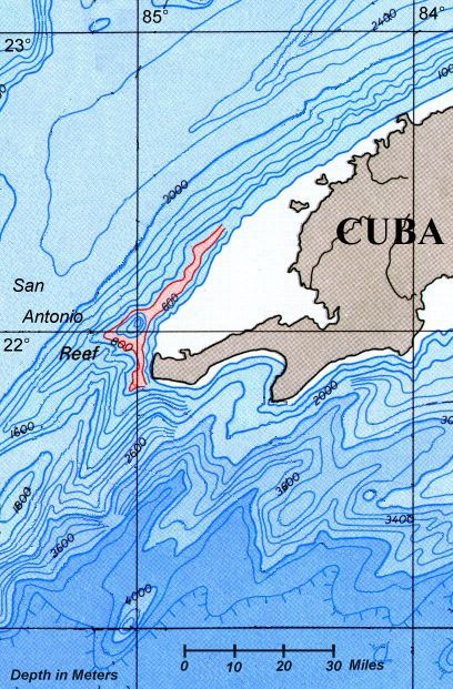
As shown on the map to the right, the most likely place for the "submerged city" to be located -- as described in the press release -- would seem to be off the western tip of Cuba. This surmise is based on the Washington Post article by G. Gugliotta (February 12, 2001), which is reproduced in part at the end of this posting.
The area of the seafloor shown in pink conforms to the press-release statement that the submerged city lies on a sandy plain beneath 2,200 feet (670 meters) of water. Note that we offer our interpretation after studying a NOAA map of the bathymetry around all of Cuba. The narrow area of the sea floor shown below in pink is the only one that seems wide enough for a plain holding the remains of a city in this region off the western tip of Cuba. Note too, that we offer our opinion under the assumption that the following points are true:
- the story is based upon evidence that is true (the story is not based on imagination), and
- that a similarly-wide area of the sea floor that runs parallel to Cuba's northern coast, beginning east of Havana and running eastward to south of Cay Sal Bank, is not the area of interest to the ADC exploration firm. That is, we infer that the area of interest to ADC is tied to the location off the western tip of Cuba where the Washington Post article below indicates that the greatest quantities of precious metals from shipwrecks are located.
Treasure in the deep? Cuba, firm aim to find out
By Guy Gugliotta. The Washington Post Staff Writer.
Monday, February 12, 2001
Twice a year, the ships of the Spanish flota set sail from Porto Bello, in what is now Panama, and from Vera Cruz, on the Mexican coast. They were loaded to the gunwales with Peruvian gold, Mexican silver and jewels from the emerald mines of Colombia.
The ships headed north to the Yucatan Channel, which separates Mexico from Cuba, before curling into the Gulf of Mexico for the run to the Havana harbor. It was there, off Cuba's western tip, that the flota faced its moment of greatest peril.
"That's the corner," Ernesto Tapanes said. "There were a lot of pirates hiding there waiting for them. And that spot probably has the largest number of hurricanes in the region."
Tapanes and his mother, Paulina Zelitsky, are the leaders of Advanced Digital Communications, a Canadian salvage company that has signed a five-year joint-venture contract with the Cuban government to chart the deep waters off the western coast and search for sunken treasure.
Last October, to test the expedition's side-scan sonar and its robot submarine, the expedition found and filmed the wreck of the USS Maine, the fabled battleship whose sinking after a massive explosion in Havana's harbor on Feb. 15, 1898, triggered the Spanish-American war.
In 1912, U.S. government salvors finished building a cofferdam around the hulk, patched it and towed it four miles out to sea, where they scuttled it with full military honors in 3,700 feet of water. To this day, historians dispute whether the Maine was sunk by a Spanish water mine, as U.S. authorities charged at the time, or by an internal explosion, as suggested by a 1976 investigation.
The ADC expedition will not answer this question, for while finding the Maine "proves that we can do what we want to do," Tapanes said, ADC wants to use its search technology to find the wrecks of treasure-laden ships that have not been seen for hundreds of years.
"We're interested in the flotas that were going to Havana," Tapanes said. Off Cabo San Antonio on Cuba's western tip and off the Isle of Youth, about 80 miles east, "we know there is going to be an extreme concentration of wrecks."
Cuba, isolated as the Western Hemisphere's lone communist outpost, has had neither the expertise nor the inclination to examine its deep territorial waters with technology that in the last quarter century has plumbed the oceans' depths far beyond anything ever contemplated by divers.
Using side-scan sonar to locate foreign objects on the sea bottom and small submarines and submersible robots to examine and recover artifacts, explorers have achieved remarkable results: discovering hydrothermal vents near the Galapagos Islands in 8,000 feet of water; filming the RMS Titanic, sunk 12,000 feet deep in the North Atlantic; and salvaging thousands of golden coins and ingots from the Gold Rush-era steamer USS Central America, lying in 8,000 feet of water off the South Carolina coast.
Under the deal negotiated by Zelitsky in 1999, ADC and a Cuban government corporation will map the deep waters off western Cuba and split any salvage 50-50. ADC expects to find a lot, and experts say the company is probably right.
"The western end of Cuba would make sense for picking up a ship from Vera Cruz, and someone coming out of Porto Bello would sail right by the Isle of Youth," said historian Sherry Johnson, a colonial Caribbean specialist at Florida International University. "The Gulf itself was called 'the Spanish lake,' so if you were a pirate, you didn't want to go there."
. . .
The ADC expedition is betting that the residue of these and other adventures lies in the ocean depths off western Cuba.
"Just by virtue of Cuba's location and history and its position on this trade route, our success rate should be very high," Tapanes said. "It alleviates the need to look for one specific galleon. If we find bottles, anchors and stuff, we can say, 'There's a wreck here,' and be reasonably sure about it."
UPDATES
See Linda Moulton Howe's June 13, 2001 article, "Update on Mysterious Deep Water Sonar Images Off Western Cuba" for more on the story.