
Archived Articles
Bimini Revisited
Introduction
This article builds upon our previous posting of January 29, 2001, entitled, “A Volcano Link To Bimini's Gold and Spar?”. We will begin by concentrating on three aspects of the current environmental situation at North Bimini. These are
- the nature of the material recently dredged from the northwestern part of the Bimini lagoon in connection with ongoing construction of a resort development there known as the Bimini Bay Resort and Casino,
- the alarming rate of natural erosion of the shoreline along northernmost North Bimini, and
- the significant modification of the natural environment planned for the northern and eastern parts of North Bimini, as a result of the Bimini Bay construction project.
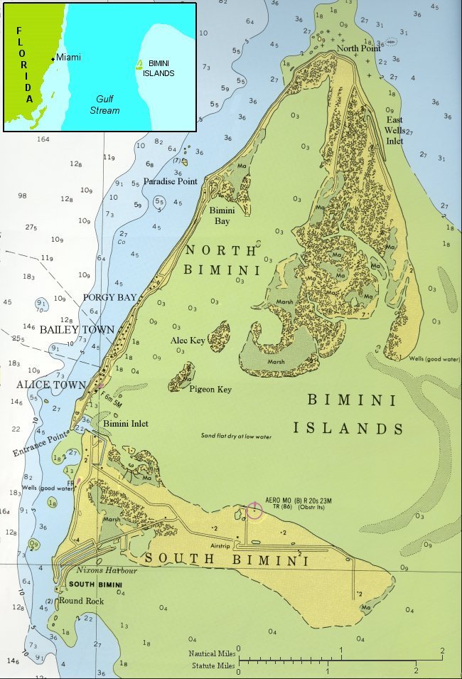 Fig. 1. The Bimini Islands, as shown on Chart 38B issued by the International Sailing Supply. Water depths are shown in meters.
 On April 22 and 23, 2002, we examined and sampled dredged materials from a new boat channel that was being dredged by the developer of the Bimini Bay Resort complex. The channel will provide a navigable link between lagoon-side boat harbors being constructed near Paradise Point (Fig. 1) and the deeper waters of the unmodified portion of the Bimini lagoon off Alice Town.
Our interest in the dredged materials stems from the emphasized words in reading 996-12 below. This reading was the last in a series of twelve, given in 1926-1927 for Thomas J. Peters, south Florida's “Tomato King” and owner of Miami's Halcyon Hotel. Peters and his associates, along with Edgar Cayce himself, had been using Cayce's powers to try to locate buried treasures on South Bimini. When these efforts failed, the group seemed to have been persuaded to devote its energies to development of “a resort equaled by none” in which both islands and the lagoon would comprise the development. The unfolding of the resort-development plan is presumed to have been given in readings 996-9 through 996-11. But we can't be sure because these readings were borrowed by Mr. Peters and never returned to the Edgar Cayce Foundation. Reading 996-12 was given March 2, 1927, in the Halcyon Hotel in Miami. Messrs. 943 and 2671 had requested the reading.
Our approach to analyzing the reading will be to start at the beginning and then break into the narrative where we desire to comment.
Mrs. Cayce. You will have before you the islands of North and South Bimini, and the submerged land adjacent to same. You will outline in detail the necessary procedure to finance and develop this project, in the way of building streets, sidewalks, sea walls, canals, harbors, sewerage, water and electrical system, ice plant, laundries, and everything necessary to complete a resort city. You will answer all questions which I will ask you regarding this.
Edgar Cayce: Yes, we have the islands as are seen in the natural formations as are visible at the present time.
Now, we find there are many things that may be said as respecting the plausibility and the advisability of making a resort city in this location. First we would give, this would not be near as large an undertaking as it appears on the face of conditions, for this may be stored away as truth for those that would go about to accomplish such conditions:
There will be found many, many, MANY sources of revenue for those undertaking such a project, for these mountain tops -especially that along the north and eastern shores of the north and northern portion of the south island - will produce many various minerals, and various other conditions that will be remunerative when the projects are undertaken; and well that the ones that do such labors - as the dredging as necessary, the building as necessary, the walls, etc. - be followed close in their operations, [emphasis added] for these will uncover many various conditions that may be turned into dollars - and dollars - and dollars!
What “Mountain Tops”?
To what “mountain tops” is the reading referring? The words, “for these mountain tops,” are among the most perplexing in this Cayce reading. The two islands of Bimini are but minor bumps of low relief, barely rising above sea level. They do lie, however, on one of several of the Bahama Banks that make up the Bahama Platform. This platform covers a huge area, equal in size to the area of the Atlantic coastal plain from Cape Hatteras to Florida. But the platform of broad, shallow banks is cut by intervening deep water channels (2,600 - 13,000 ft deep) that make it unlike any other topography on the Atlantic margin of North America.
If all of the waters of the Banks were to disappear, the Banks themselves would appear as mountains. In this sense then, one might suppose that islands like the Bimini Islands, the Cat Cays, Andros, and other smaller islands could be considered the very tops of the mountain of carbonate sediment known as the Great Bahama Bank. Our work on the upcoming pole shift predicted in the readings indicates that only a one-degree shift of the north pole to 89.0° N, 60.0°W would produce a decrease of approximately 965 ft in sea level in the vicinity of Bimini. Such a lowering of sea level around the Great Bahama Bank would undoubtedly result in a visual impression of a mostly flat-topped type of a mountain rising out of the ocean. Observers of the scene would be looking at a steep-sided mass of mostly grayish-white limestone standing roughly 1000 ft above the surrounding waters.
And on the top of this “mountain” minor peaks could be seen here and there. Like Bimini, they would have mostly been formed out of former sea-floor sands that had been blown up into dunes and then cemented by percolating rainfall during times of lowered sea level. Note that this speculation has nothing to do with the documented sea level of around minus 400 ft that coincides with the peak lowering at the height of the last ice age, some 19,000 to 21,000 years ago. No, we are supposing here that one of the many pole shifts spoken of in the Cayce readings played its role in lowering sea level even further than 400 ft at Bimini, during Atlantean times. Thus, the psychic impression that came through Cayce was one in which he saw the Bimini Islands as “mountain tops,” on what we today call the Great Bahama Bank.
Sampling Recently-Dredged Materials
At this point we want to bring you up to date on our examination of dredged material from the new boat channel that has been excavated for the Bimini Bay Resort project. Note that the location over which we sampled the materials does not correlate exactly with “that along the north and eastern shores of the north and northern portion of the south island,' as highlighted in bold in the reading above. But the reading says that many sources of revenue will be found for the project, “especially” along the specific shores mentioned -- not exclusively along them.
Thus, it seemed reasonable to investigate dredged material taken both from 1) the relatively long channel and 2) the boat harbors being constructed near Paradise Point. (See Figure 2). The channel and harbors lie not too far from the northern shore of the north island.
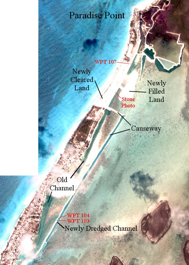 Fig. 2. Portion of satellite imagery of the Bimini Islands taken in late February 2002. [Image-acquisition costs for this map were paid out of funding from Edgar Cayce Foundation].
 Figure 2 is a satellite shot taken in late February 2002 of the dredged channel (blue) and the road constructed of dredged material (white) on the west side of the channel. The design depth of the channel itself is 15 ft deep and was roughly this depth everywhere when we visited Bimini. The channel had been dredged by shovels (Fig. 3A), because the limestone was so hard in places that it had to be ripped out of the bottom using specially built buckets.
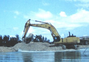 3A. One of the shovels used to dredge the new channel. It is shown here digging up the temporary causeway made from the dredged material. New channel is in the foreground.
 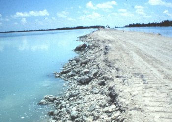 3B. The temporary causeway used by haul trucks for removal of the causeway itself. The new channel is on the left of the causeway.
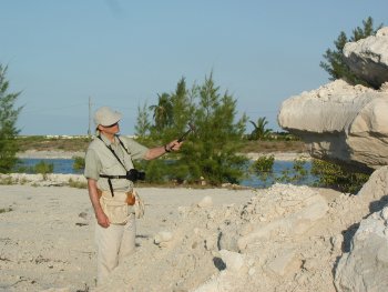 3C. W. Hutton at a rock pile dumped from truck in the filled area just east of Paradise Point.
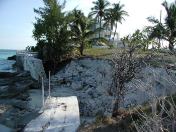 3D. Extent of erosion at Paradise Point (looking north, with Gulf Stream on left).
After bringing up the lagoon-floor limestone, the dredged material was shaped by road-building equipment (Fig. 3B). Shovels and trucks are now (May 2002) removing the dredged material, transporting it to an area of filled land to the north (Fig. 3C), thus removing the road and restoring the environment. In effect, then, we had a “tape recording” of the lagoon- bottom material to sample when we visited Bimini.
We rented a boat and began our work at the south end of the temporary causeway. Mr. Eagle operated the boat and the GPS equipment, while Hutton walked the shorelines of the road and broke rocks with his geologist's hammer. During this time he recorded various observations, and took small rock samples for later analysis. After our sampling-trip along the road was completed we moved north by boat to investigate the shoreline materials in the filled-land areas and along the shores of the small harbors under development.
At no time did we see any dredged materials that were clearly unusual, although we did sample all rock fragments that were “somewhat unusual” in appearance. The most unusual looking samples were found at GPS-located sites 103, 104, and 107. (See Fig. 2). Because sample 107 was taken along the shore of a recently filled area is impossible to know its true point of origin. Our general impression of the limestone materials that were ripped up from the lagoon floor, and which make up the road and filled areas, is that they are part of the cemented carbonate sediments that nearly everywhere form the uppermost consolidated rocks of the
Sample Analysis -- Golden Hues
Preliminary Work. Upon returning home, the three most-interesting samples were immersed in hydrochloric acid until the carbonate matrix had dissolved. Residues remaining were then washed with pure water, collected on filter papers, and dried. The filtrates were examined with a 15-power magnification hand lens.
Sample 103, although sampled for its seemingly greater density than other samples, left a residue so small that only a few, tiny black flecks could be seen.
Sample 104, black in appearance before dissolution, exhibited a small residue of tiny black flecks. Interestingly, after dissolution the surface of the wash water before filtration exhibited small “oily” patches. These patches were not analyzed. Note that the sample was fresh and had not been contaminated in any way by machinery oil in the field.
Sample 107's residue after dissolution looked like brown mud in the wash pan. After drying, hand-lens examination showed large numbers of small black mineral grains (up to roughly 1/4-mm in diameter). Many of these displayed golden-hued surfaces made up of a different mineral, attached to the black surfaces of the larger underlying grains. The golden-hued minerals did not look like native gold and I (Hutton) thus assumed that they must be pyrite (iron disulphide), or “fools gold.” I could also see a few small quartz sand grains in the sample residue.
ICP Determination of Metals. To make sure that I had not mistakenly identified some of the golden-hued minerals, and because gold is sometimes distributed invisibly through pyrite, I had the bulk residue of sample 107 analyzed by the inductively coupled plasma (ICP) method at a commercial laboratory. The ICP results showed no gold, at a detection limit of 0.0019 percent, or 19.50 parts per million of residue. Some 15.9 percent of the residue was iron, consistent with the notion that pyrite is present. Cadmium and lead were less than 0.002 percent, copper less than 0.001 percent, while zinc was 0.005 percent, nickel was 0.006 percent, and chromium was 0.007 percent of the residue.
Origin Of Sample 107 Residue. The best work that is being done these days on exotic sources of non-carbonate materials in sediments and rocks of the Bahamas seems to be that by scientists at the Coastal and Marine Geology Program of the U.S. Geological Survey's Center For Coastal and Regional Marine Studies in St. Petersburg, Florida. They have worked mainly on the health of coral reefs in the Caribbean as influenced by far-traveled dust storms of the Saharan Desert. Their work is understood to extend also to a consideration of Saharan-dust inputs to the Bahama Banks.
Desert winds carry more fine sediment than any other geological agent and the Sahara probably moves 60-200 million tons/yr of dust. An increase of dust has been correlated with periods of drier and/or windier climates in arid regions. Each year some of the material picked up in the Sahara Desert is transported in the atmosphere across the Atlantic Ocean, and some is deposited on the Bahama Banks. Red-iron and clay-rich soils on carbonate islands throughout the Caribbean are known to be of Saharan dust origin (Muhs et al., 1990).
The clayey residue found in sample 107 most probably originated in the Saharan Desert. The pyrite crystals in the residue probably precipitated onto the surfaces of the black iron-mineral fragments when sulfur-bearing waters circulated through limey carbonate mud before consolidation and cementation.
We continue now with reading 996-12.
In considering the manner and way that this project would be financed, we find these conditions are to be considered: First, in the various congested centers in which there are almost innumerable individuals that have achieved success in the financial way and MANNER, these - by the natural tend, or natural trend of human thought and human endeavor to gain from life those pleasures that bespeak of the effort as has been put forth - are seeking such outlets for a way to not only invest, but to build new and different modes and manners and ways for such pleasures. Acting, then, against the natural tend and bent of the inlander, as it may be termed, these are seeking such times, such places, that they may enjoy the fruits of their labors.
Again, this is as a truth which may be stored away again. Not expressed by those who would endeavor to make a resort or a city here. There are, as has been given, many peoples being born again into the earth's plane who were through their experiences in this land. With the building then, again, we find the innate desire will come to an innumerable number to be in SOME manner or way associated - either as dwellers for a portion of the time or the whole time, or as the investers [investors?] in the project - to make this not only a habitable place, but as a resort equaled by none.
Now, as to the reasonableness, and how this may be gone about:
There is seen that the general lay of the land, and the surrounding territory or vicinity, or the natural lay of those waters nearby - these lend themselves, in a natural way, to the establishing of many, many, many acres - many miles of acres of territory. That not reclaimed, as it were, but the naturalness of conditions is to bring forth not ten, but hundredfold - for the labor and the time spent.
There will be seen that on the northern portion of south island will lend itself to the water supply, which is one of the first considerations of such a place. A sweet water. One that lends itself to that of being adaptable, not only for the drinking purposes, but for all purposes of the human body. This will be found by drilling to the depth which will be, true enough, below the sea level, yet the source is from far - far - away. Better water will be found than in those lands known as the continents.
Speculating On The Origin Of The Potable Water
We infer from the reading that the water would not originate in Florida, on the continent, but that the source would be on an island some distance away from Bimini. If so, what would be the conduit for such “sweet” water? And which island would be large enough, to collect enough fresh water, and (in places) high enough, to set up a U-tube type of groundwater flow? Later on below in the reading we come across this Q/A exchange:
Q. How deep will we have to drill for the fresh water?
A. Eight hundred and ninety-two (892) feet.
Q. What supply would that obtain?
A. One thousand eight hundred gallons (1,800) per hour.
Q. Could an additional supply of water be obtained by going deeper?
A. This is the strata for the water. Other supplies may be obtained in various portions near here, which would only increase the amount if necessary. This supply would increase, see?
Q. Would this be Artesian?
A. Artesian.
Q. It would flow out of the top?
A. Flow out over the top.
For 1,800 gallons per hr of water to “flow out over the top” of the hypothetical well would require flow to originate on a higher, larger island and then to flow, via a well, to the less elevated surface of South Bimini. Artesian flow at Bimini would thus occur by classical U-tube type of flow in which the higher arm of the “tube” is the end on the higher island. Our conjecture is that only Andros Island, to the southeast of Bimini and the largest island in the Bahamas but still on the Great Bahama Bank, would qualify.
The groundwater recharge area would presumably be northern Andros Island, which lies about 80 to 110 miles from South Bimini. If this seems a reasonable conjecture, we would then have to assume that for the fresh water to remain uncontaminated by salt water and to keep the water under sufficient confinement to allow for artesian flow when tapped by drilling at South Bimini, the water would have to flow in a stratum of limestone sealed both top and bottom.
This last requirement may be asking a bit too much of the groundwater environment of the Great Bahama Bank because seawater circulation was encountered in the Great Isaac Island wildcat well (Fig. 1) in most of the upper 6,500 ft drilled. Below that depth, both sealed conditions and structural closure were encountered. Anhydrites present in that part of the geologic section, similar to that in southern Florida, appear to form effective seals (R.E. Sheridan, And Others, 1988, p. 360).1
Continuing on with reading 996-12, we read:
This also lends the modes of manufacture - of electro-hydro power in the waves, if necessary, by the tides - such as have been and are being builded in the Bay of Fundy - for with the walls as may be built in the western coasts of the inlet - which may be closed or left open, or builded for the purpose of an inland sea for the boat, the port, and for the fishing, bathing, and the like - this may be builded in such a manner on the northern shore of the south, and the southern shore of the north island, as to facilitate the power sufficient to electrify the whole of the lands that may be acclaimed and reclaimed.
How Viable Is Wave And/Or Tidal Power For
Electrifying A Resort Complex At Bimini?
Our passing familiarity with studies of generation of electricity via machinery that captures the power of waves tells us that the waves around Bimini do not lend themselves to this type of power generation - at least not using any machinery known today. Waves of sufficient power are simply too intermittent to be useful.
As for tidal currents, we have been in touch with an expert in this area who initially wrote to us on another subject. He is an executive with a company that specializes in the generation of electrical power from tidal flows, using specially designed turbine generators. In response to his interest in Cayce's readings, we sent him detailed information from a publication on tidal current velocities in the Bimini Inlet.2 The article documents tidal currents over a nine-day time series, for two depths at each of eight current-meter stations. Ebb flow was found to be about 30 percent longer than flood flow. We questioned our expert about whether the maximum ebb-tide current speeds of 1.7 kts, and maximum flood-tide current speeds of 1.4 kts, would be sufficient to satisfy the reading's suggestion.
He wrote back to us to the effect that while power could be obtained for the reported velocities, he wondered if it would be cost-effective power. He said that the current speeds were generally weaker than those they want as minimums but, depending on the location, bathymetry, blockage ratios, and so on, “something might be made of them because of the massive volumes [of water] involved in that area.”
Reading 996-12 then goes on to discuss the likely sources of funding for such a project, suggesting that
...a combination of Detroit, Cleveland, London and Paris, be that which would be the more satisfactory for those who would undertake to bring about that which would prove, in this place, as the resort premier above others - for this may be accomplished in this place; for, as given again, this may be stored away by those who would undertake such: There will be within these developments many things that have as yet not even been thought of or considered, that would not only of THEMSELVES attract the great horde, but would also attract great wealth - for this is of the first highest civilization that will be uncovered in some of the adjacent lands to the west and south of the isles, see? Ready for questions.
Q. Is this the continent known as Alta or Poseidia? [Atlantis]
A. A temple of the Poseidians was in a portion of this land.
Q. What minerals will be found here?
A. Gold, spar, and icthyolite [?].
Q. How deep in the ground will that be found?
A. In the wall that would be builded from the western portion of the south island towards that of the PROMINENT portions of the southern portion of isle - these will be found in the twelve to fifteen (12 to 15) foot levels. The VEIN, as workable, would be found extending in the northeast-southwest direction. The waters in the northern portion of the south island. Sweet water, see?
Q. Give the exact longitude and latitude of the vein?
A. In this we have the island - in this we have the place.Find these, or locate. These are known.
Q. What amount will be necessary to complete development?
A. From seventy-five to ninety million.
The Gold Vein And Associated Minerals. Note that our analysis of the above portion of reading 996-12, which covers the gold vein and associated minerals, is given in a previous article. To this we would only add a bit more information about the possible significance of the proximity of Bimini to the Bahamas Fracture Zone (BFZ). Figure 4 shows the trend of the BFZ in the crust beneath the Bahamas and into south Florida. The BFZ is a major fracture zone that has been mapped on the floor of the Atlantic Ocean. Where it exists beneath a cover of sedimentary rocks, its trend has been interpreted from geophysical surveys. We have plotted the trend of the BFZ on a magnetic anomaly map modified from Sheridan and Others.1
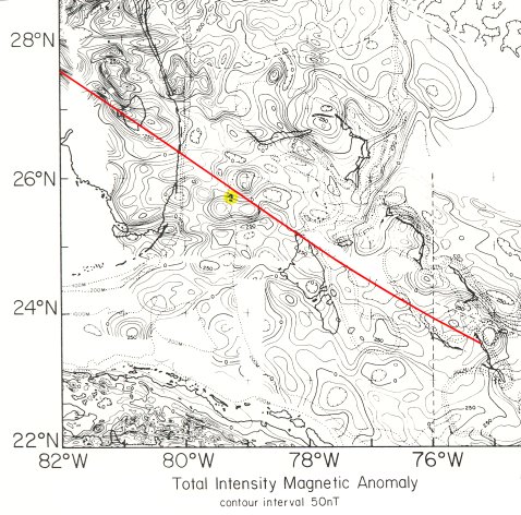 Fig. 4. The interpreted trend of the Bahamas Fracture Zone (BFZ), as superimposed on a portion of a total-intensity magnetic anomaly map of the Bahamas region (Sheridan and Others, 1988, Fig. 16). The Bimini Islands are located within the yellow dot.
 In our earlier article on gold at Bimini we said:
“Pure (“native”) gold has been found in many of the volcanic terranes of the ocean floor and,
'with sea-floor spreading [in the Jurassic Period], the large outpouring of volcanics in the Bahama area may have developed a shallow plateau of oceanic basalts similar to Iceland. As in the Iceland-Faeroe Ridge structure, the Bahama volcanic crust could have formed a shallow, linear ridge feature parallel to the general Bahamas Fracture Zone flow lines.' (R. E. Sheridan and Others, 1988, The Geology of North America, Vol. I-2, Geol. Soc. America, Washington, D.C.)
“Gold minerals are few in number, if it is minerals that 996-12 is referring to. Calaverite is a gold telluride consisting of AuTe2, with small amounts of silver. Although this is a rare mineral, in Australia and Colorado it is an important source of gold. Note that the Bahamas fracture zone runs just north of Bimini, trending NW by SE. The linear ridge feature mentioned above, therefore, could underlie the Bimini Islands.”
To this we would add that reactivation of volcanic emissions along the BFZ could have occurred as late as 12,000 years ago during the time of the final demise of Atlantis in the Azores area. Or the BFZ could have become reactivated earlier (19,400 B.P.) when several readings say that a man-induced catastrophe caused the portion of Atlantis near the Sargasso Sea to go “into the depths.” This volcano-like upheaval separated Atlantis into five islands and produced a pole shift that caused the ice sheets to begin to melt in Europe, Asia, and North America.
In any event, it could have been by such crustal disturbances that volcanic activity could have been reactivated, sending gold-bearing fluids upward into fractures in the overlying limestone of the northwestern Great Bahama Bank. One of these fractures could have trended in a northeast southwesterly direction, at roughly a right angle to the trend of the BFZ and coinciding with the trend of the Bimini Inlet. By digging 15 feet below the bottom of the inlet one would be at a proper depth to encounter gold-bearing rocks of the required age (somewhere between 19,500 to 12,000 B.P.).
The Spar Minerals. In connection with the reference in 996-12 to the occurrence of “spar” minerals, take a look at Figure 5. The boulder-sized block that is shown appears to have been dredged somewhere along the new channel, and then hauled to the fill area. (See Figure 2 for the location of where the photo was taken).
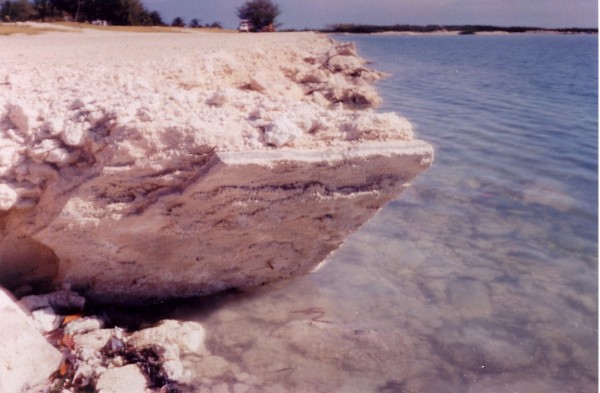 Fig. 5. A large boulder and contained slab that was apparently dredged from the new channel. Photo taken by William Donato in early October, 2001.
 We looked for the boulder on our trip to Bimini but could not find it. Most likely it was incorporated into the fill that now exists in the former “old channel” shown on Fig. 2, near the point where it was photographed. The tabular feature of a few inches in thickness looks like it might be composed of calcite spar. Spar is “a term loosely applied to any transparent or translucent light-colored crystalline mineral, usually readily cleavable and somewhat lustrous, especially one occurring as a valuable nonmetallic mineral; e.g. Iceland spar (calcite).”3Then again, the tabular layer might be magnesian calcite,3 or even dolomite. Other similar materials will undoubtedly be found as dredging proceeds.
The importance of an investigator being “on the spot” during dredging operations becomes evident. Only then can the location and approximate depth of origin of unusual materials be noted and recorded.
Reading 996-12 continues on, dealing again with sources of financial support for the project. These sources are irrelevant today. The reading then turns again to deal further with the best source of fresh water and with the development of an adequate port facility.
Q. How deep will we have to drill for the fresh water?
A. Eight hundred and ninety-two (892) feet.
Q. What supply would that obtain?
A. One thousand eight hundred gallons (1,800) per hour. The electro-hydro power would be made from that condition as may be builded, as given, which would supply all of the power necessary for any project that might be - might be - even undertaken here; for this would become not only a strategic point in the affairs of this - THIS - continent, but of others - as it has been in the eons past.
Q. Could an additional supply of water be obtained by going deeper?
A. This is the strata for the water. Other supplies may be obtained in various portions near here, which would only increase the amount if necessary. This supply would increase, see?
Q. Would this be Artesian?
A. Artesian.
Q. It would flow out of the top?
A. Flow out over the top.
Q. Is there any sulphur in this water?
A. Sulphur may be obtained here. THIS is sweet water here.
Q. Give the chemical analysis.
A. Fifty-six percent (56%) pure water. Silicon a trace.
Lime a trace. Magnesia a trace. This would be pure sweet water here, you see, with only the traces of those of silicon, magnesia, of lime, and of other properties as only would be seen in traces of same, see? And in the changes as brought, as given, this may be only increased by the heating, or the various conditions as may be brought to same - for, as a health resort, as the building up of the general body, and as of the whole system, see?
For the reading to say that the water to be obtained is 56 percent pure water is certainly a strange way to put it. Does this mean that the remaining 44 percent is impure water? Or - by some strange way of calculating - does the reading simply mean that 44 percent of the water will contain traces of silica, lime, and magnesia? Also, the flow of 1,800 gal per hr for the well seems hardly enough for a resort complex, even though the reading does indicate that additional water supplies could be obtained “near here.”
Drilling a test well to a depth of 892 ft in the northern part of South Bimini would be an interesting project to verify Cayce's psychic powers. If potable artesian water were to be found at this depth, it would not only verify the prediction but the water would also be useful to the local citizens as an emergency supply, if a severe hurricane or other disaster were to hit the islands. The type of “other disaster” that we have in mind is mentioned at the end of the article.
We continue on now to the end of the reading.
The sulphur waters may be obtained where there is seen an old channel on north end of the south portion of north island. These, we find, will be of the black sulphur, yet for certain conditions - and for the baths as may be instituted through same - will be quite beneficial to health, and especially to those of the neuritic conditions - nervousness, and of the germ of rheumatic conditions, see? This will be found only eighty-nine to ninety (89 to 90) feet deep, see?
Q. Could this port be made a shipping port?
A. Be made a shipping port, by the opening of the channel to the west and to the north here, see?
Q. What would be the proper way to open this channel?
A. See, when a channel is made here - as we see, the sands only come from the southern end, that would hinder or produce a bar. When dredges are made, only the extension of those obstructions - that only divert the channel - which is of moving waters - to the outer edge, would prevent and keep from the bar being moved back and forth across. Rocks or piles, see? Along this end.
Much may be given, and much may be accomplished - and as to those that would build such, that as is given as "keep in store" is, as it were, the bonus for the undertaking. Keep that for self.
We are through for the present.
Copy to Mr. [943] Copy to Mr. [2671]
996-12; March 2, 1927
The Environmental Situation On North Bimini Today
Coastal Erosion. A serious situation has developed with regard to erosion of the coast of northernmost North Bimini. Figure 6 shows the history of shoreline retreat deduced from air photos for 1943, 1955, 1967, and from a satellite image for 2002. The shoreline traces could not be corrected to a common tide stage. This accounts for the overlap of the 1943 and 1955 shorelines near the south-westernmost ends of the shoreline traces shown. Nevertheless, the overall retreat of the shoreline is dramatic for the 59-year period involved. It ranges from zero to an average maximum retreat of 12 ft/year. A small lake and a pond have most recently been impacted near the northernmost point of land. (See Figure 6).
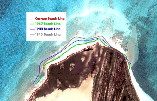 Fig. 6. Shoreline positions over the last 59 years, as inferred from air-photo and satellite images. The year 2002 satellite image was prepared by THC's web master J. Eagle.
 In 1970, I prepared a report based on air-photo and beach-profiling studies that showed how the shoreline might be protected. The suggested remedial measures are summarized in Figure 7, as adapted from my report. One assumes that a repeat of the profiling work and coastal-engineering calculations would lead to similar recommendations today.
My report recommended immediate construction of spending beaches for shoreline protection. But nothing was ever done. A spending beach is a temporary sand fill that offers beach protection for several years as the fill is slowly distributed along the coastline by longshore currents. Breaking waves set up longshore currents in the breaker zone and shoreward of it. They transport sand roughly parallel to shore. If a hydraulic dredge were available, a better source of sand than that in the “Proposed Borrow Area” (Fig. 7) could be obtained from a borrow area that could be established just north of East Wells Inlet. The sand could be pumped by the dredge through a temporary pipeline to the designated fill areas.
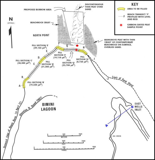 Fig. 7. Proposed spending beaches for North Bimini, showing fill locations and volumes, proposed borrow area, and profiling transects. The location of dated peat samples is also shown (see text for an explanation).
 Carbon-dated peat samples reflect shoreline erosion over a longer period of a minimum of 18 centuries. In early February of 1972, Profs. R. Macqueen and R. Byrne of the University of Toronto conducted a study of the mangrove vegetation in the lagoon close to North Point. They noticed that the mangrove peat there extends under the present sand beach and out into the ocean. They traced the remains of the old lagoon mangrove into the sea at least 400 feet due north of North Point (Fig. 7) and found that the peat varied between two and four feet in thickness along the path that they took. A sample of peat taken at the low-tide mark was dated at 895 A.D. ±110 yrs and another taken 217 ft further out to sea was dated at 85 A.D. ±110 yrs. (Teledyne Isotopes' Westwood NJ Laboratories did the dating; sample numbers I-6456 and I-6455, respectively.)
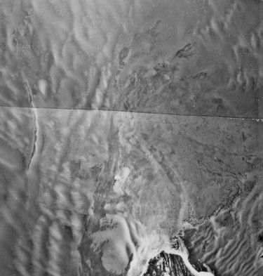
The age of the peat indicates that erosion has been taking place for quite a long time and the air-photo compilation of Figure 8 shows a long history of shifts in the shorelines (now underwater) off North Point that have led to losses of beaches and headlands as the shoreline retreated. The process continues today (cf. Figure 3D), and something must be done to stabilize the present shoreline before breakthroughs to the lagoon occur, upsetting the lagoon's hydraulics.
Locating The "Old Channel"
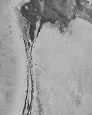
We studied the oldest air photos that we could obtain in attempting to locate the "old channel" mentioned in the reading fragment above. It appears to be located where the strip of land comprising the west coast of North Bimini narrows markedly just south of Paradise Point. Figure 8 shows a break in the shoreline features there and what appears to be a narrow channel to the east on the lagoon floor. This lagoon-floor channel shows up on both the 1943 and 1945 air photos, and it points right toward the disturbed area of the coastline where an old interchange of coastal and lagoon waters may have taken place. Thus the "old channel" seems to be located "on the north end of the south portion of [the] north island," near Bimini Bay (Fig. 1). And, inasmuch as this channel is located on the south side of Paradise Point, its position there protects it from southward moving sand eroded from the North Point's retreating shorelines. If the narrow part of the island were dredged to make a shipping channel, the new channel could be opened "to the west and to the north" into the Gulf Stream." It would then make sense to protect the new channel from northward drift of sand in the longshore-current system by constructing a rock jetty on the south side of the ocean entrance to the harbor.
 |
 |
 |
 |
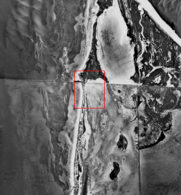
| Fig. 8. Mosaic of 1943 aerial photography. Note former beachrock shoreline features on the ocean floor to the west and north of N. Bimini, and the rough correspondence of ancient (submerged) coastlines and headlands. Inset shows 1945 image of broken shorelines and "old channel." These features are also discernable in the smaller red box on photography taken two years earlier. | |
Environmental Modifications Resulting
From The Bimini Bay Resort Development. Several impacts to the natural environment should be mentioned.
Impacts to water plants. In 1971, North American Rockwell Corporation was developing a plan to construct a marina and tourist/resort complex on roughly the same land now owned by the developers of the Bimini Bay Resort and Casino project. Mr. Byrne, mentioned earlier, was commissioned to make a brief reconnaissance survey to assess the impacts that proposed dredging and filling operations would have on vegetation. Clearly, the greatest impact would be to plants growing close to sea level, specifically the mangroves.
There are four mangrove species in the area:
- Red mangrove (Rhizophora mangle)
- Yellow buttonwood or Black mangrove (Avicennia nitida)
- Black buttonwood or White mangrove (Laguncularia racemosa)
- Black buttonwood or Buttonwood (Conocarpus erecta)
The red mangrove can grow only in areas flooded by the tide. If the land surface is raised above tidal range the red mangrove will be unable to survive. The yellow buttonwood, or black mangrove as it is sometimes called, is usually found on somewhat higher ground than the red, and it is less sensitive to filling. The white mangrove is a comparatively rare species, ecologically similar to the black mangrove but vulnerable because of its limited numbers. The buttonwood grows in slightly brackish water and would be replaced by fresh-water tree species if the level of the land were raised.
All of the above are common species throughout the Bahamas and the New World tropics in general. They are well adapted to natural disturbances, such as hurricanes, and will reassert themselves after dredge-and-fill operations have been completed, assuming that suitable habitats are still available. They have little or no economic value.
Although there are no strong arguments for preserving the mangroves themselves, loss of nursery grounds from dredging can seriously impact fish populations. Also, it is well recognized that mangroves play an important role in stabilizing sediments in the inter-tidal zone. Removal of mangroves over large areas could therefore have undesirable effects such as silting of boat channels and the like.
Impacts to terrestrial plants. Most of northern and eastern North Biminiis covered by typical Bahamian evergreen scrub. The species presentare widely distributed throughout the Bahamas. Like the mangroves, they are adapted to a certain amount of natural disturbance. However, as can be seen on northwestern Bimini, if the introduced Australian Pine (Casuarina) is planted in disturbed areas it quickly eliminates the native species.
Note that many of the native species have a stabilizing effect on unconsolidated dune sand. Too rapid removal of the vegetation cover may result in wind erosion. This actually happened in the area on the northwestern side of North Point around 56 years ago when the native vegetation was removed to plant coconut trees.
Recommendations. Figure 7 shows the location of transect A-A' along which indigenous native plants were collected. Figure 9 shows the interesting variety of plants collected along this transect by R. Byrne and his students. In contrast to north-west North Bimini and South Bimini, northeastern and southeastern North Bimini are relatively undisturbed by man. This makes the area desirable for a natural preserve.
Tourists are becoming more ecologically minded and would likely appreciate being able to see a pristine Bahamian-island landscape. The lower half of the land area below transect A - A' (Fig. 7) would be best suited to this purpose. It could be made accessible to tourists with the aid of board walkways through the bush and mangrove swamps, as has been done, for example, in Florida's Everglades National Park. Bahamian plants are for the most part unknown to North Americans and for this reason alone are interesting. Displays could be arranged illustrating Arawak and Negro uses of local plants, bush medicines, and so on.
TRANSECT ACROSS N.E. BIMINI (A-A' on Map in Fig. 7) |
|||||||||||||||||
| Buttonwood | Conocarpus erecta | ||||||||||||||||
| Red Mangrove | Rizophora mangle | ||||||||||||||||
| Black Mangrove | Avicennia nitida | ||||||||||||||||
| Herbs |
|
||||||||||||||||
| Coastal Scrub |
|
||||||||||||||||
| Evergreen Woodland |
|
||||||||||||||||
| Fig. 9. Plants collected across transect A - A' (Fig. 7), in northeastern NorthBimini. | |||||||||||||||||
Bimini's Future - As Inferred From The Readings
Few of the environmental plans or concerns mentioned above will be of any consequence if the pole shift and associated Earth changes predicted in the readings begin soon. The following two reading fragments tell us why.
Q. Is this [Bimini area] the continent known as Alta or Poseidia?
A. A temple of the Poseidians was in a portion of this land [somewhere near Bimini on the Great Bahama Bank, in all probability].
996-12; March 2, 1927
And, as may be known, when the changes begin, these portions [of, as a minimum, the Great Bahama Bank near to and including Bimini] will rise among the first.
587-4; July 1, 1935
Our model for just a small, one-degree pole shift shows that, just after the shift, the Bimini area will be high and dry. The surface of the Great Bahama Bank will have “risen” a minimum of some 965 feet relative to sea level. The Bimini lagoon will be a dried up mud flat, suddenly stinking as its formerly abundant marine life rots in the sun. Winds will later heap former sea-floor sands into dunes, and dust storms will sweep across the broad barrens of the great Bank. The mangroves will disappear and the islands' marinas and hotels will be empty of boats and tourists.
But soon a new type of visitor will be seen as the island peoples adjust to the great natural disaster that has befallen them. Many of these new visitors will doubtless be reincarnated Atlanteans looking for a Poseidian temple, long lost but whose memory is buried in the subconscious. Complementing these adventurous ones will be archaeologists, seekers after gold and mineral wealth, and chroniclers of an unfolding new paradigm of Earth history.
They will uncover a story the likes of which no one could have imagined. It will be the revelation of Atlantis, Queen of the Sea. Ultimately, the story will cover the beginning, rise, growth, and destruction of that ancient prototype.
Archibald MacLeish referred to the rise The Metaphor.
An age becomes an age, all else beside, When sensuous poets in their pride invent Emblems for the soul's consent That speak the meanings men will never know But man-imagined images can show; It perishes when those images, though seen, No longer mean.
The truth will come out about the former glories and failures of the Atlanteans. And the world will benefit from the promise of our understanding of her history and its meaning for humanity's future. This history will be but prelude to a different future, however; as a new Atlantis returns on a higher plane. And it will be a future to which all men of the new cycle will bow, in cooperation one with another. As reading 364-8 indicates:
...He will walk and talk with men of every clime. Then in groups, in masses, and then shall reign of the first resurrection for a thousand years; for this will be when the [Earth] changes materially come.
- Sheridan, R. E., and Others, 1988, “Geology And Geophysics of the Bahamas,” The Geology of North America, v. I-2, The Atlantic Continental Margin: U.S., The Geological Soc. of America.
- Harrison, W., and others, 1970, “Field Study of a Tidal Inlet, Bimini, Bahamas,” Proc. Twelfth Coastal Eng. Conf., Washington, D.C.
- Bates, R. and J. Jackson, 1987, “Glossary of Geology,” Amer. Geol. Institute, Alexandria, VA.