
Archived Articles
The Message Of The
Alaskan Earthquake And
Ecuador's Volcanoes
Alaskan Earthquake And
Ecuador's Volcanoes
Background
In reading 3976-15, given in 1934, Edgar Cayce channeled an important message for humanity from archangel Halaliel. It said to watch for:
“upheavals in the arctic and antarctic that will make for the eruption of volcanoes in the torrid areas, and there will be a shifting then of the poles - so that where there has been those of a frigid or the semitropical will become the more tropical, and moss and fern will grow.”
Without addressing the “upheavals” at this time, it seems important to bring to subscribers' attention the fact that certain torrid-area volcanoes are suddenly showing unprecedented activity. This activity may represent precursors to imminent commencement of pole shift.
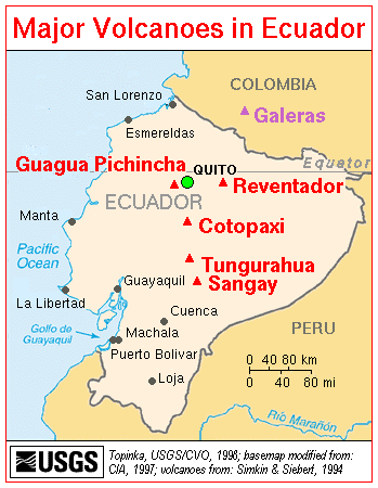
Why are Revantador, Guagua Pichincha, and Tungurahua all erupting now? Let's first consider the recent eruptive history of these volcanoes.
Reventador is a frequently erupting volcano. It sits almost exactly on the equator, and should therefore be a most sensitive indicator of the beginning pole shift, as Earth's crust starts to move ever so slightly over the equatorial bulge.
Since the beginning of the 1958-1998 period, during which time reading 3976-15 also said that the Earth changes would begin to be apparent, Reventador has erupted five times (1958,1960,1972, 1973, and 1976). It began erupting strongly again on November 3, 2002.
Guagua Pichincha, after having been quiescent for 100 years, erupted weakly in 1981, 1985, 1990, and 1993. Magmatic eruptions occurred again in October 1999. Intermittent eruptions of varying scale since then have blanketed Quito and surrounding towns with ash. Last week, explosions occurred at Guagua Pichincha on November 3. Ash plumes could not be distinguished from those of Reventador, which was also erupting last week.
Tungurahua began erupting in October of 1999. It had last erupted in 1944.
Local Effects of Reventador's Eruptions
Here are some of the effects of Reventador's latest eruptions, as extracted from a report of the UN Office for the Coordination of Humanitarian Affairs.
On Saturday, November 9, 2002, El Reventador continued to show a high level of activity, expelling steam, ash and lava. The Geophysical Institute in Ecuador estimates that the volcanic activity will continue for some time but predicting the intensity of it is difficult. An Emergency Committee, headed by the Ministry of Social Welfare, has been established to co-ordinate, together with the National Civil Defense, the relief assistance in response to the crisis.
Infrastructure (electric power, telecommunications, transport): The electric power was suspended in many areas in the provinces of Pichincha, Sucumbios and Napo, due to the ash falling into the transformers and to fallen power lines. During the first hours of the event, telecommunications were also affected and in the areas near the volcano this service has still not been restored. In general, roads to and from the affected areas are clear. The exception is the road between Baeza and Lumbaqui, where the pyroclastic flows and lahars have destroyed two road bridges. The international airport in Quito remains closed.
Agriculture: the agricultural sector is the most seriously affected. The short-cycle crops and the flower plantations are seriously damaged. The pastures, covered with ash, cause digestive problems to livestock, and milk production has decreased substantially. The Chaco zone, in the immediate vicinity of the volcano, is the most affected, where ash fall has completely destroyed
pasture and crops, the main economic activity of the rural communities. In Cayambe, more than 8,000hectares of crops (vegetables, grin, fruit trees) have been affected. In addition there is a concentration of commercial flower growers in Cayambe and Pedro Moncay, whose production is seriously affected.
Housing: The population cleared roofs quickly to avoid damage. In general, the housing sector has suffered minimal damage.
How Can Polar Upheavals Cause Torrid-Area Volcanic Eruptions?
Earth's torrid areas lie roughly between the Tropics of Cancer and Capricorn, or approximately latitudes 23.5°N and 23.5°S of the equator, respectively. Once again, Halaliel's message, as channeled through Cayce in reading 3976-15 says:
“There will be the upheavals in the arctic and antarctic that will make for the eruption of volcanoes in the torrid areas, and there will be the shifting then of the poles...”
Stated clearly here is the proposition that eruptions of volcanoes in the torrid areas can be induced by crustal upheavals in the arctic and antarctic. This seems to imply that upheavals in the polar regions must be of sufficient magnitude to start to unbalance the rotating Earth and induce the poles to attempt to shift. Such activity will cause those volcanoes located near to, or on either side of, the equatorial bulge in the torrid areas to respond to the incipient pole shift.
Any attempt of the overlying mantle and crust to move over or away from the equatorial bulge will cause sufficient disturbance to cause magma to rise into many of the torrid-area volcanoes. Volcanoes closest to the eventual shift meridian could be expected to be the most eruptive. We believe that the shift meridian will be close to the 60° W longitude; see our article entitled Calibrating The Hutton Commentaries' Model For a 1° Pole Shift to 89.0°N. This is important because Ecuador's volcanoes are within 18° of the 60° W longitude.
The idea here is that, as a region of the crust and mantle straddling the incipient shift meridian tries to move toward the equator, it must cover a somewhat larger area (or, in three-dimensions, fill a greater volume). But there is insufficient material available to do so. On the other hand, any torrid-area mass trying to move away from the equator is subjected to contraction, as there is an excess of material available.
In regions of existing torrid-area volcanism, such disturbances of the crust and mantle related to pole shift would be sufficient to facilitate magma flows. Such magma flows would very often lead to eruptions through paths of least resistance in the crust. These would be paths through incipient fractures and existing volcanoes. Old fractures could also be reactivated, allowing magma to move through them.
J. Campbell did some provocative work on shift of the mantle and crust over the equatorial bulge for C. Hapgood's book entitled, The Path of the Pole (1970, Chilton Book Co., New York). For example, consider Figure 2 below, adapted from Fig. 34 in Hapgood's book. The figure shows diagrammatically the pattern of faulting and folding during displacement of the crust and mantle. Only one meridional fault (the shift meridian) is shown, which is moving toward the equator in the northern hemisphere. The dotted lines indicate other faults opening from the bottom of the crust as the arc of the surface diminishes. Across the equator, where the crust is moving toward the pole, and compression is resulting, the continuation of the major expansion fault is shown as a pressure ridge. Dashed and solid vertical lines designate other crustal fractures that may be expected to parallel the major meridional fracture.
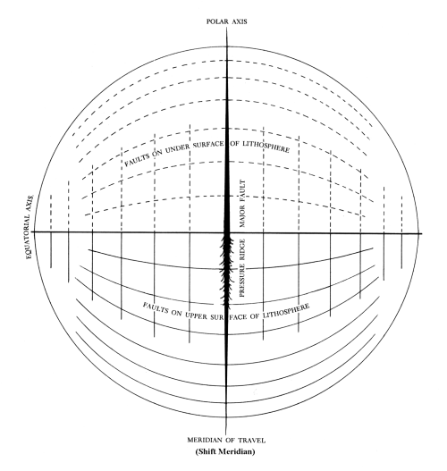 Figure 2. Fractures resulting from movement of the mantle and crust over the equatorial bulge.
Now we have just been talking about the incipient motion of the mantle and crust over the equatorial bulge. Magma can follow paths through fractures under stress; fractures that are trying to begin to open fully from the bottom of the lithosphere in the quadrant moving toward the equator, and through fractures trying to open fully through the top of the lithosphere. Pre-existing volcanoes that are already magma conduits will tend to erupt first.
For our hypothesized global shift meridian of 60.0°W and 120°E, the most eruptive volcanoes will be those in a broad torrid-area region from Indonesia and the Andaman Islands, eastward to the Philippines, New Guinea, New Britain, and the Bismark Archipelago. Note that the 120°E shift meridian is within only 15° of the super-eruptive volcano of Krakatau and within only 2° of Tambora.
In the Western Hemisphere, the most sensitive and eruptive volcanoes will be those extending from southern Mexico, central America, and the Caribbean Leeward Islands, to the Galapagos Islands, Columbia, Ecuador, Peru, Bolivia, and northernmost Chile and Argentina in South America. The subset of volcanoes that will erupt most vigorously will tend to be those closest to the equator in the torrid areas, as well as those nearest to the shift meridian. Thus, the volcanoes of Indonesia and Ecuador (includes the Galapagos Islands) are the centers of the most dangerous volcano regions in their respective hemispheres.
Remember here that there are two volcanoes capable of super-eruptions that are now in early eruptive phases on the opposite side of the Earth. They are Pago (5.6°S, 150.5°E) and Rabaul (4.3°S and 152.2°E). Both are on the island of New Britain.
The Alaskan Earthquake's Connection To Ecuador's Volcanic Eruptions
We have always used the 63°N latitude as the southern boundary of the “arctic” region for the purpose of checking for “upheavals in the arctic and antarctic” (reading 3976-15). Note that the epicenter of the Alaskan earthquake of November 3, 2002 was slightly north of this latitude, at 63.47°N.
At M 7.9, this huge quake - with its accompanying robust aftershock series and 65-mile-long rupture zone - certainly qualifies as an upheaval in the arctic. Is it just a coincidence that Reventador erupted three or four times on November 3 and 4? Do we not have here the near-perfect sequence of an upheaval in the arctic coinciding with the eruption of a torrid area volcano? And along with the eruption of Guagua Pichincha on November 3 we seem to have a perfect match. That is, an upheaval in the arctic and the eruption of torrid area volcanoes (plural).
The match is not completely perfect, however, if one looks at the timing of the Alaskan quake relative to the eruption of Reventador. The huge Alaskan quake occurred at 22:12:41 UTC (Universal Time, Coordinated: 22 hr, 12 min., 41 sec), on November 3, 2002. Within 20 minutes, the quake's seismic waves reached the most distant points on the planet from the focus of the quake beneath Earth's surface.
The initial large eruption at Reventador - the first in 26 years - occurred close to 14 hrs UTC. This was about 8 hours before the big quake occurred in Alaska. Note, however, that a strong M 6.7 foreshock of the M 7.9 quake occurred 11 days earlier, on October 23. This was followed by a number of additional foreshocks (in the M 3.0-3.9 and 4.0-4.6-ranges) that occurred up until the mainshock of November 3.
Guagua Pichincha's eruption occurred close to 01:45:00 UTC, on November 4, about three and one half hours after the massive Alaskan earthquake. This is more in keeping with an impulse-response type of model that derives from a straightforward reading of 3976-15; that is, a model in which an upheaval in the arctic or antarctic will cause an almost immediate eruption of one or more volcanoes in the torrid areas.
But consider just below the operation of a less tightly time-constrained impulse-response model for the general eruptions of Ecuador's torrid-area volcanoes, due to crustal or volcanic upheavals in the arctic and antarctic.
Tungurahua exhibited various eruptive activities during the October 30 - November 5, 2002 reporting period. This volcano, however, had begun its eruptive activity in October 1999 (its first since 1925). Guagua Pichincha also began its present eruptive cycle in October of 1999. These volcanoes' eruptions may have been initiated by the more than 200 light-to-moderate earthquakes that were measured between January and August of 1999, along the submerged Gakkel Ridge in the high arctic (centered roughly at 85.7°N, 81.4°E). (The submarine volcanism (another kind of “upheavals”) that accompanied these quakes has now been well documented).
Then again, perhaps it was the great (M 8.2) Balleny Sea earthquake off Antarctica that caused Guagua Pichincha and Tungurahua to begin to erupt in concert. This quake took place in March 1998, and was the largest ever detected within an oceanic crustal plate. Its location and great strength were completely unexpected by the world's seismologists.
Conclusion
The message of the Alaskan quake and Ecuador's newly erupting volcanoes seems clear. Three of Ecuador's volcanoes are erupting simultaneously. Two of these began erupting about the same time as the Alaskan quake. To those of us who follow the Cayce readings these events have to be taken as a sign that the poles may be about to shift.
Earth changes accompanying the pole shift will be catastrophic. The initial days of the pole shift seem described in parts of 3976-15.
As to the material changes that are to be as an omen, as a sign that this [return of John the Beloved] is shortly to come to pass - as has been given of old, the sun will be darkened and the Earth shall be broken up in diverse places...
The Earth will be broken up in the western portion of America. The greater portion of Japan must go into the sea. The upper portion of Europe will be changed as in the twinkling of an eye. Land will appear off the east coast of America.
These historically unprecedented Earth changes might occur over several hundreds of years. This is so because geological evidence of tectonic, volcanologic, and seismic activity during the period from about 19,000 to 8,000 years ago shows that such pronounced Earth-change activity occurred many times, in several-hundred-year-long stretches. And that past activity was a follow on, presumably, to the pole shift that began [if the Cayce readings are correct and if I have reasoned correctly from them] around 19,400 years ago. We thus could expect the same sort of duration of continuing planetary effects to coincide with, and follow, the forthcoming pole shift.