
Archived Articles
Rocks of Atlantis May Have Been
Found Beneath Bimini, Bahamas
Found Beneath Bimini, Bahamas
Early- To Mid-Pleistocene-Age Rocks Found At Shallow
Depth Represent A "Record In The Rocks" Of
The Once Great Continent
Background to the Discovery of a Significant Geological Disconformity at Bimini
Investigating the possible existence of Atlantis can be exhilarating. Especially so when retrieving rock cores from the deck of a drilling barge positioned in the sparkling waters of the Bimini Inlet.
This is the story of a geological investigation conducted by William Hutton and Jonathan Eagle, of The Hutton Commentaries, in March, 2007. The article also covers certain follow-on activities required to document our encounter with a completely unexpected geological disconformity, there in the carbonate-rock and sediment strata beneath the Bimini Islands. Fossil coral ages and a C-14 date lend credence to a statement made in an Edgar Cayce psychic reading which indicates that evidence of Atlantis may be found in Bimini.
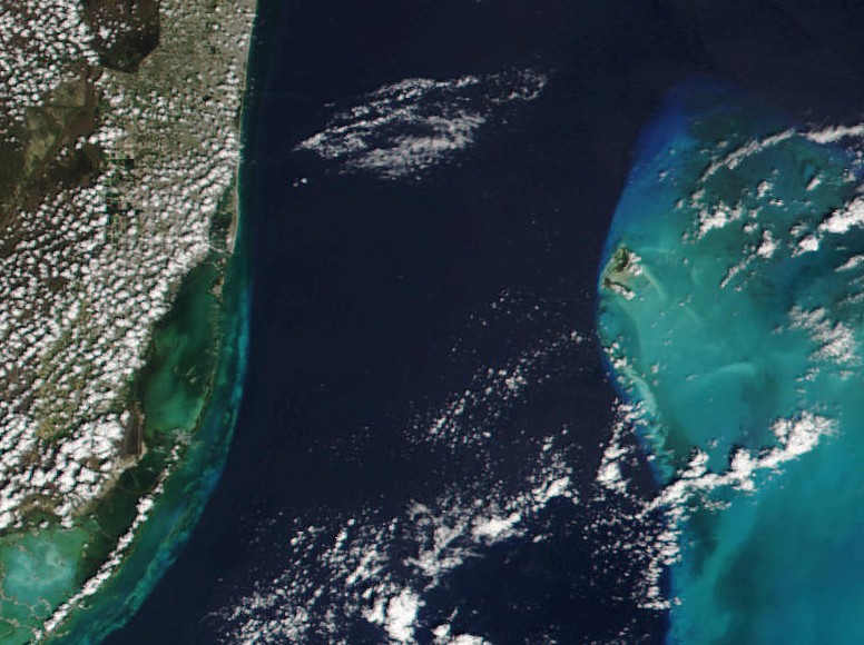 Figure 1. NASA image showing the Straits of Florida (dark blue) bracketed by southern Florida on the left and the Great Bahama Bank on the right. The Bimini Islands are visible where the Great Bahama Bank juts out into the Straits of Florida.
 But first, where did the idea of making a geological survey at Bimini come from?
In our latest book, "Earth's Catastrophic Past and Future, A scientific analysis of information channeled by Edgar Cayce," we explored recent developments in geological paradigms that make the concept of lost continents more plausible. This after a generation during which the plate-tectonics hypothesis seemed to rule out the possibility. We also listed specific geological evidence from the mid-Atlantic ridge that very directly addressed the question, "Could the legendary continent of Atlantis have existed, physically?"
The Edgar Cayce psychic readings raise the possibility, in a pronounced way, that Atlantis actually existed. One of Cayce's channeled discourses, in his Atlantis series of readings, says the following.
…while the destruction of this [Atlantean] continent and the peoples are far beyond any of that as has been kept as an absolute record, that record in the rocks[emphasis added] still remains….
The position as the continent of Atlantis occupied, is that as between the Gulf of Mexico on the one hand – and the Mediterranean upon the other. Evidences of this lost civilization are to be found in the Pyrenees and Morocco on the one hand, British Honduras, Yucatan and America upon the other. There are some protruding portions within this that must have at one time or another been a portion of this great continent. The British West Indies or the Bahamas, and a portion of same that may be seen in the present – if the geological survey would be made in some of these – especially, or notably, in Bimini [emphasis added] and in the Gulf Stream through this vicinity, these may be even yet determined.
(364-3; February 16, 1932)
In 1932, at the time of this reading, there were really only two conventional methods available to investigate the “record in the rocks.” The first was to obtain rock cores by drilling from a barge in Bimini's nearshore waters, or by coring subsurface rocks on land. Inspection of surface outcrops on Bimini would have been useless in 1932 because surficial rocks of Bimini are only a few thousands of years in age. (Cayce readings 364-4 and 288-1 indicate that the final destruction of Poseidia, the last island of Atlantis, took place between 12,700 and 11,900 BP [years before the present]).
The second type of investigative method in the 1930s would have involved making ship-based dredge hauls to recover rock fragments from the steep cliff wall on the shelf edge beneath the Gulf Stream off the west coast of Bimini.
Thus, from the perspective of the source of reading 364-3, it seems that such 1932-vintage methods for verifying the reality of Atlantis could have been most effective, but perhaps only at Bimini. And the information channeled by Cayce for reading 364-3 implied that rock sampling might in some way reveal the presence of former Atlantis.
So why would anyone want to investigate a psychic reading that required one to spend time and money drilling in the submerged rocks beneath Bimini? Does not everyone know that the Bimini Islands are just a couple of largely cemented dune-sand landforms sitting atop of upwards of 17,000 feet of carbonate rocks? And that these rocks are full of coral fragments deposited over many millions of years?
Furthermore, just how good was Cayce's source for his Atlantis readings, when it came to visioning Bimini's subsurface? Maybe one could find out, we thought, by talking to water-well drillers who had logged some of the holes that they had drilled on Bimini.
A Visit To a South-Florida Well-Driller's Office
In February of 2006, William Hutton, Jonathan Eagle, and Alfredo Salas were able to confirm the geologic picture of Bimini's subsurface, as described in the reading fragment just below. We did this while meeting with a south Florida water-well driller whose staff had drilled two relatively deep test wells on North Bimini. The driller provided us with a report of the logs of the wells cored.
... sulphur waters may be obtained where there is seen an old channel on north end of the south portion of north island. These, we find, will be of the black sulphur, yet for certain conditions - and for the baths as may be instituted through same - will be quite beneficial to health, and especially to those of the neuritic conditions - nervousness, and of the germ of rheumatic conditions, see? This will be found only eighty-nine to ninety (89 to 90) feet deep, see?
(996-12; March 2, 1927)
Figures 2 and 3 show the locations, relative to the “old channel on north end of the south portion of north island,” of the two test wells drilled within the past five years on North Bimini.
|
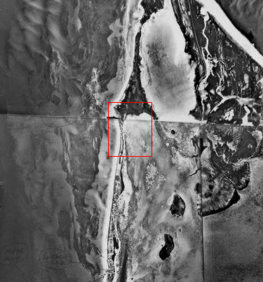
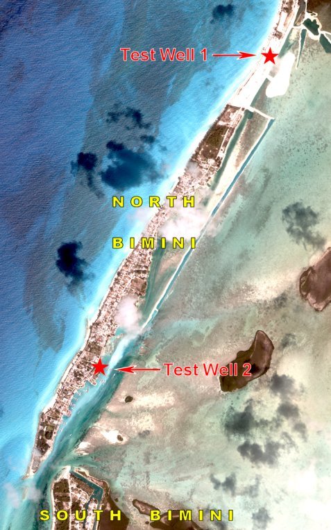 Fig. 3. Approximate locations of Test Well 1, a 200-ft-deep well, and Test Well 2, a 400-ft-deep well. The Bimini Inlet is seen in the lower left-hand corner.
 In terms of Cayce's reading extract above, we are primarily interested in the log of Test Well 1 because it refers quite clearly to the depth at which sulfur water was encountered. The driller at the moment of encounter said that the odor of sulfur was so strong that it almost forced him to leave the drill rig.
The log of Test Well 2 will provide information supporting the statements found in the reading relative to the black color of the sulfur water found in the vicinity. These two test wells were drilled and cored for prospective desalinization plants on North Bimini. The logs for each well were prepared by a student Ph.D. candidate in geobiology.
Relevant Portions Of Log of Test Well 1
Here is the unedited log prepared by the student. (Only one sentence, on the conductivity of water in each well, was left out.) Hutton's comments on some of the geologic terms are given in italics, and placed in curly brackets. Words in bold font are done so for emphasis by Hutton.
The core was predictably unconsolidated sediment for the first 20 ft and then lithified calcium carbonate for the rest of the core. The core below 20 ft was mostly wackestone, packstone, and grainstone with some instances of rudstone.
{Wackestone is a mud supported carbonate sedimentary rock containing more than 10 % grains; packstone is sedimentary carbonate rock whose granular material is arranged in a self-supporting framework, yet also contains some matrix of calcareous mud; grainstone is essentially mud-free carbonate material; and rudstone is a carbonate rock composed of bioclasts of other fragments, over 2 mm in diameter, closely packed, in physical contact; the interstices may be open, or filled with fine carbonate sediment or crystalline cement.}
A number of subaerial exposures {of the carbonate sediments in the well core} were noted, indicating sea level regressions and transgressions. These exposures were marked by small solution cavities, darker staining of the rock and in some cases iron coloring and black pebbles. Coral became evident at 70 ft and continued down core. At 130 ft, Stylophora sp was identified, indicating that a date during the Pliocene had been reached. (Stylophora sp became extinct after the Pliocene.) The first 70 ft was very permeable and the water, distinctly clearer. Hydrogen sulfide was encountered at 90 ft-100 ft, and was present downcore.
Here we have clear confirmation of the passage in Cayce reading 996-12 that states that sulfur water will be “found only eighty-nine to ninety (89 to 90) ft deep.” But what about black sulfur water? The student's log for well 2 continues below.
Relevant Portions Of The Log of Test Well 2
The second well, to be used privately by the Big Game Club, was drilled to 400 ft. The lithology was very similar to the first well, being wackestone, packstone and grainstone. Subarieal exposures were noted again and these correlated with the core of the first site reasonably well. Stylophora sp was encountered at 130 ft. Smaller coral pieces were encountered compared to the first well. This is to be expected, however, as coral usually grows patchily and not in a uniform manner. Below 200 ft the lithology was fairly similar, with considerable burrowing. Hydrogen sulfide was reached at approximately 120 ft.
Under the heading of “Notes,” on a page that accompanies the well log for Test Well 2, one finds that the student had written:
120 ft H2S
130 ft H2S
140 ft H2S, black water400 ft artesian water pressure (H20 comes up in pipe on its own)
Here, then, we have confirmation of black sulfur water, at 140 feet in Well 2. And the information about artesian water pressure at the 400-ft depth suggests that the strange statement, also in Cayce reading 996-12, about the flow of sweet water over the top of any well drilled for a potable water supply in the northern portion of South Bimini, may also be true.
Two aspects of the above findings, and of our Cayce readings' interpretations, prompted us to make our own investigation of the subsurface rocks at Bimini. The first aspect that prompted us was the clarity of geologic vision displayed in reading 996-12's description of Bimini's subsurface. The second was the identification of "Stylophora sp, at 130 ft, which became extinct after the Pliocene," by the person who logged the two bore holes. If that identification was correct, it would mean that much older rocks of Pliocene age are far closer to the surface beneath North Bimini than one would have expected, and that a lot of Pleistocene-age sedimentary rocks would be missing from the geologic section.
Such a gap of time, represented by missing rock strata, is the definition of a geological disconformity. A disconformity is marked by evidence of erosion during a break in sedimentation, in which the bedding below the erosion surface is parallel to that above; that is, there has been no deformation of the lower series of beds prior to erosion.
Notes in the two student logs indicate that the test wells may have encountered several disconformities. Even one disconformity at Bimini would be quite significant. It would tell one that at a time when sea level was lower than 130 ft below present sea level — as was the case between roughly 120,000 to 13,000 years or so ago — an ancient land surface would have been exposed beneath what is now the Bimini area. This would tend clearly to validate the Atlantis-at-Bimini story of Cayce reading 364-3.
The emergence of a carbonate terrain above sea level, when sea level had dropped by up to 300 to 400 ft during the last part of the Pleistocene epoch, would have produced a lowered base level for the discharge of ground water. This situation would have permitted meteorically derived fluids to penetrate the "elevated" terrain more deeply, contributing to secondary porosity and the formation of karst topography. Examples of secondary-porosity solution channels can be seen in Figures 9 and 14.
This was the case for development of the karst in major carbonate aquifers in the Southeast coastal plain of the United States during the Holocene (last 10,000 years). Sinkholes are the primary landform found in mature karst terrain, and if the above-sea-level phase of the last lowering of sea-level at Bimini resulted in some sink holes in the Bimini area, one such closed depression could have become the "well" mentioned in Cayce reading 587-4.
(Q) Could the well in Bimini be promoted and reconstructed?
[Stenographer's note: Mrs. [587] told Edgar Cayce that after her "life" reading {a type of reading covering a series of past lives} she had flown to Bimini and had found a freshwater well marked, or walled around the top, with stones of peculiar composition and strange symbols.]
(A) There has been much given through this source [996 & 996-12] as to how that particular portion of what was the Atlantean period might be developed. While it would make for much outlay in money, as ordinarily termed, there are certain interests that would join IN such an undertaking. As those of the Dodge interests, as given. For it could be established as a center for two particular purposes; a regeneration for those with certain types of individual ailments (not only from the well, or water from same, but from the surrounding waters - because of the life in same), and a center for archaeological research. And as such activities are BEGUN, there will be found much more gold in the lands under the sea than there is in the world circulation today!
(587-4)
The question then became, could we duplicate the findings of the person who logged the boreholes on north Bimini. If so, how? One cannot just go around on Bimini drilling exploratory holes to his heart's content. He must first obtain a permit from the Government of the Bahamas.
Serendipitously, we suppose, we already had a Bahamian permit to drill into the rocks beneath the waters of the Bimini Inlet. We had obtained the permit to look for geochemical signatures of an igneous intrusion. This because we had indications, from our previous magnetic and geochemical studies there, of a buried volcano or volcanic intrusion, at an unknown but shallow depth, in the carbonate rocks. We decided, then, to drill exploratory holes to take rock cores for the dual purpose of investigating both the bedrock stratigraphy and the minerals of any igneous intrusion into the carbonate country rock beneath the Bimini Inlet.
We also decided to drill at the three points shown below, using a jack-up barge to ensure stability of the drilling rig on the deck. GPS locations for each core-hole are given in the appendix at the end of this article.
 Fig. 4. Locations of the three exploratory bore holes in the Bimini Inlet. Hole 1 is now in open water because the sand spit was removed by hydraulic dredge after the satellite image was obtained. Hole 2 is close to the "rock" where three samples were taken in a previous THC study of rare-earth element concentrations in cemented sandstone, concentrations that increased with depth below the bottom.
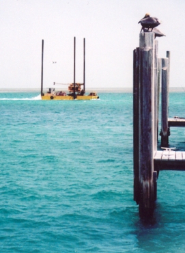
We chose to contract with a Miami well-drilling company that already had a jack-up barge in the Bahamas. The drill crew was experienced in over-water drilling. Here is a picture of the barge moving along in the Bimini lagoon with its three legs lifted high so as not to drag its feet on the lagoon floor.
GPS positions of the "drilling well"
on the barge were also recorded
at each drill hole.
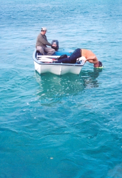
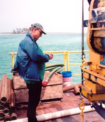
When moving the drilling barge to drill hole 2, we found that there were many more utility cables and pipes running across the inlet floor between North and South Bimini than we had indicated on Figure 4. It became imperative that the feet on the legs on the jack-up barge not be placed on any of the utility cables and pipes. This required careful observation of the feet as the barge was being positioned for each drill hole. Here one sees one of us checking the barge-leg feet. A diver's mask was used as a "sighting glass" to get a clear view of the inlet floor as the barge was maneuvered into position for drilling.
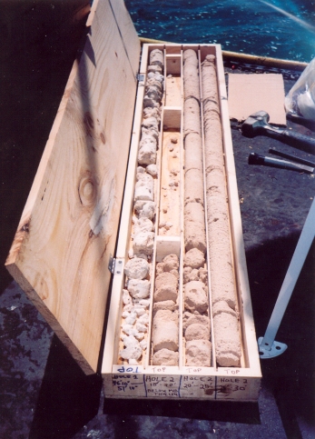
All cores taken were put into core boxes for later shipment to the U.S. for paleontological and chemical analyses, and for C-14 dating of core samples.
After our field work, we noted a large piece of coral at a depth of 45 ft in core-hole 2. (See Fig. 9). This was identified by two university geobiologists as Colpophillia breviserialis, a type of brain coral found in the Bahamas during the late-Pliocene to early-Pleistocene. Another sample in core 2, at the 48-to-49.5 ft depth below MSL, contained rudstone, an indurated carbonate mud with shell fragments of Turritella type gastropods 15%, worm shells 10%, ribbed bivalves 15%, and non-ribbed bivalves 60%. (See Fig. 10). Associated with this assemblage was Montastrea I-franski, a type of boulder coral found in the Bahamas during the early to mid-Pleistocene. (See Fig. 11).
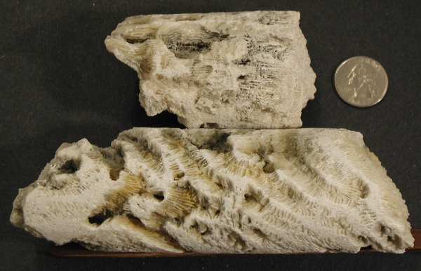 Figure 9. Colpophillia breviserialis, found at -45 ft in core 2. Secondary porosity in the form of solution channels and/or Lithophaga borings is shown.
 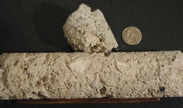 Figure 10. Rudstone containing shell fragments of Turritella type gastropods, worm shells, ribbed bivalves, and non-ribbed bivalves, found at -48 to -49 ft in core 2.
 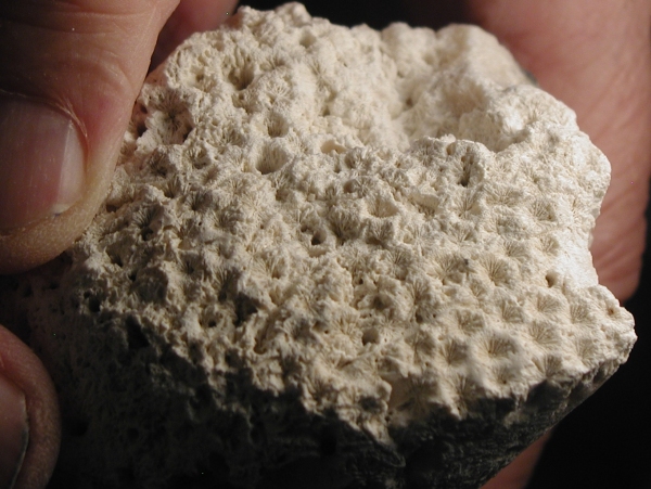 Figure 11. Montastrea I-franski found at -48 ft in core 2.
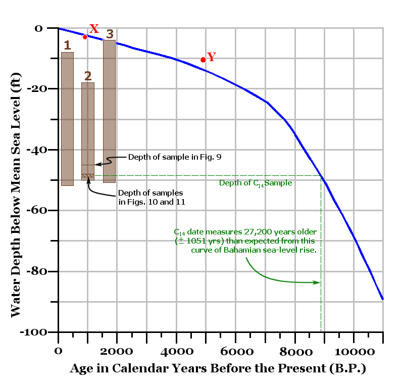
Fig. 12 - The blue curve is for relative sea-level rise for the entire Bahamas. It is based on numerous C14 dates for intertidal peats and shallow reef-crest corals. It reflects a reasonable demarcation between intertidal peat data (maximum sea-level) and shallow reef crest A. palmata data (minimum sea level required to submerge coral). The sea-level rise curve was constructed by Toscano and Macintyre (2003) who wrote as follows. "All {rates of sea-level rise} are well below the maximum accretion rate of A. palmata and are not indicative of extreme pulses capable of effecting reef drowning and subsequent backstepping." X and Y denote C14-corrected dates for Bimini intertidal peats.
From this blue curve alone, the expected age of the limestone sample in borehole 2, at -48.5 ft., should have been about 8,900 BP. (Refer to the black horizontal axis of the graph.)
But because it has a minimum C14 age of about 36,000 BP, it is a minimum of 27,200 years older than would be expected from its position on the blue curve in the graph.
Taken together, the ages of these fossil corals indicate that we had cored rocks of early-Pleistocene age at the minus 45.0-to-49.5 ft level below current sea-level, there in the middle of the Bimini Inlet. A piece of cemented carbonate silt from the 48.5-ft depth was C-14 dated to 36,100 ±1050 years BP. However, there are clear indications that the reported result represents only a minimum age and that the true age may in fact be older. The measured C13/12 ratio of -5.6 o/oo was more depleted (more negative) than is typical for a sample containing carbonates from a strictly marine environment (typically marine values range from -2 o/oo to +2 o/oo). As such, the C13/12 ratio may be indicating the presence of carbon from post-depositional sources, due to the dissolution, recrystillization, replacement or alteration of carbonates transported by fresh water or rainwater. If that carbon was from younger or even modern (post-1950 AD) sources, the reported radiocarbon age could have easily been biased in the more recent direction by varying amounts.
As an example, consider that if the true age of a hypothetical carbonate rock is, say, 100,000 years, and it contains as little as 1% contamination by post-1950 AD carbon, the C-14 age determination would yield a result of approximately 37,000 years BP. Contamination by younger, but not necessarily modern carbon could also have very large effects depending on the amount and actual age of more recent contaminants contained in the rock.
Therefore, the 36,100-year-old radiocarbon age of the limestone rock at -48.5 ft in borehole 2 is only a minimum age. It provides a "youngest possible" age for the rocks containing the fossil corals identified above. Thus, if the corals at -45 ft and -49 ft represent early to mid-Pleistocene age, then they could be between about 1,800,000 to 400,000 years old. (The "early-Pleistocene" epoch, or the Lower Pleistocene Calabrian epoch to geologists, is represented by rocks between 1.81 to 0.78 million years of age. Mid-Pleistocene age rocks are younger.)
We have examined the stratigraphic implications of all three cores with respect to the probable boundary between the Lower Pleistocene rocks and the overlying, Holocene rocks and sediments. (The Holocene covers the last 10,000 years of Earth history.) If we turn now to the sea-level curve for the late-Pleistocene (Fig. 13) we see that the old land surface of Atlantis could have been above sea level since roughly 120,000 BP.
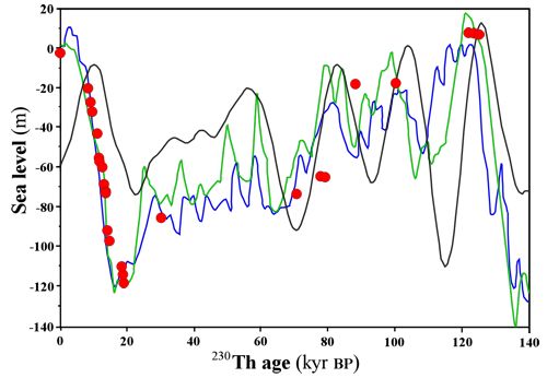 Figure 13. Global changes in sea levels from 2000 to 140,000 B.P. Source: Edouard Bard, Bruno Hamelin, and Richard G. Fairbanks, "U-Th Ages Obtained by Mass Spectrometry in Corals from Barbados: Sea Level During the Past 130,000 Years," Nature 346 (1990): 456–458. Note that the curve of relative sea-level rise for the Bahamas (Fig. 12) should take precedence, for the period 0-5,000 BP, over the curve in figure 13, for corals from Barbados which is in a slightly more tectonically active location.
The limestone that contains solution channels from minus 10 to minus 26.8 ft in borehole 1 (see the Appendix), is highly suggestive of a former land surface that has been subjected to surface-flowing freshwater, or rainfall, in the past. This uppermost, solution-channeled limestone stratum may be of the same mid- or lower-Pleistocene age as the rocks stratagraphically below it, at about minus 35 ft in boreholes 2 and 3. (See descriptive logs in the appendix.) If so, that suggests that the ancient land surface of Atlantis would presently be only 10 ft below mean tide level at the location of exploratory borehole 1. Additional work is needed to confirm this supposition.
Conclusion
Evidence of fossil coral ages, as backed up by a C-14 date, indicates that a considerable thickness of Pleistocene and Holocene strata is missing from the near-surface geologic section beneath the Bimini Inlet. A reasonable implication of these missing rocks is that, during a period of time covering perhaps 800,000 years -- or a minimum of 120,000 years at the least -- an ancient land surface in the Bimini area could have been above sea-level during times of continental glaciations when ocean water levels were depressed due to the oceanic water mass locked up in ice sheets. That ancient land surface could have been the continent of Atlantis.
But, one asks, "What happened to that continent; where is the remainder of it today?"
To answer this question requires one to enter into the great geologic controversy of the last 40 years; that is, the controversy between those who believe in plate tectonics and sea-floor spreading vs. those who credit largely vertical crustal motions as the true explanation for global tectonics. Because we have a serious problem with the plate-tectonics group-thinkers (see chapter 25 of our book), we would simply say that legendary Atlantis just sank, during a series of geological catastrophes between 19,400 and 12,400 BP. This explanation, advanced in a series of Cayce readings, makes as much sense to us as do the stories advanced by the followers of plate tectonics for oceanic crustal movements.
The uppermost Bimini disconformity is significant because it implies an environment that could have been inhabited by an ancient civilization for thousands of years. In Cayce reading 364-3, that former human environment and ancient land surface is implied in this way.
"... a portion of same {Atlantis} that may be seen in the present, if the geological survey would be made ...especially, or notably, in Bimini... "
We have now completed a small first step in a geological survey of Bimini. Indeed, we may have even "seen" a portion of Atlantis in the rock cores recovered. Further field and laboratory work is being planned, with emphasis on the analysis of the core samples for their abundances of rare-earth elements.
Acknowledgments
We want to thank the many unnamed people who have helped our Bimini research along over the last months and years. Their names have not been listed here to avoid their suffering the consequences of ridicule, or even career impediment, for having helped with research based upon psychically-derived information.
You will not be forgotten, and if some day you wish to be cited in updates of this article we will be most pleased to do so.
Appendix
GPS locations of the core-hole stations in the Bimini Inlet
GPS locations of the core-hole stations in the Bimini Inlet
| Latitude | Longitude | |
| Core Hole 1: |
N 25° 43' 9.4" | W 79° 17' 55.6" |
| Core Hole 2: |
N 25° 43' 11.1" | W 79° 17' 58.7" |
| Core Hole 3: |
N 25° 43' 10.6" | W 79° 18' 2.6" |
Core Descriptions
Here follows descriptions of the cored strata taken from exploratory borings 1, 2, and 3 (see Fig. 4).
Hole 1. The uppermost 2.0 ft of hole one consists of loose sand. Between 10 ft below mean sea level and minus 26.8 ft there was 85 per cent recovery of gray limestone with small to moderate-sized solution channels. (See Fig. 14).
 Fig. 14. Solution channels and borings at minus 10 ft (left), and minus 16 ft, in core 1.
 From 26.8 ft to the bottom of the hole there was 25 to 50 percent recovery of gray to white limestone containing considerable solution cavities and channels up to one-half inch in diameter. At minus 35 to minus 36.6 ft a layer of cemented shell hash was recovered. Note that this is quite possibly the same layer as the one encountered at this same depth in hole 3.
Between minus 41 and 47 ft the drill core-barrel returned 50% of a layer of cemented shells with numerous solution cavities. And from minus 47 ft to 51.5 ft the core barrel returned 90% of a layer of limestone with medium-sized shells and coral fragments. Ninety per cent recovery of this stratum exhibited numerous solution cavities and channels, and medium-sized shells and coral fragments.
Hole 2. The top of this core, from minus 18 to 20 ft was composed of moderately well cemented, light-tan-colored sand with some borings and/or solution channels. (60% recovery). From minus 20 to minus 30 ft the core barrel recovered 95% of light tan, cemented, bedded sand with some solution channels around minus 23-25 ft. This sand became white down hole. Between minus 30 to minus 35 ft there was 95% recovery of cemented white sand. From minus 35 to minus 40 ft there was only a 2% recovery of hard, thumbed-sized coral fragments, and between 40 and 44.5 ft, only 3% recovery of the same material. A roughly one-ft-long piece of Colpophillia breviserialis coral was encountered at minus 44.5 to 45.5 ft. Another shorter piece of Montastrea I-franski was encountered at minus 49.2 to 49.6 ft.
Hole 3. We recovered only uncemented sand in this core from minus 4 ft to minus 10.8 ft. From minus 10.8 ft to minus 25.8 ft we had 60% recovery of weakly-cemented tan sand that became more whitish downhole.
From minus 25.8 ft to minus 40 ft light-tan, cemented sand with considerable solution channels was recovered (90% recovery). Cemented shell hash occurred between minus 35 to minus 36.4 ft. Note that this is quite probably the same layer encountered in hole 1.
From minus 40 ft to minus 45.8 ft we had 70% recovery of a fine white limestone matrix containing small to medium-sized white shells. And below minus 45.8 to 50.8 ft there was only 20% recovery of fragments of fine white limestone.