
Archived Articles
Sea-Level Change In The Vicinity Of
A.R.E. Headquarters - Now Until 2025
A.R.E. Headquarters - Now Until 2025
How Much Higher (or Lower) Will Sea Level Be in The Vicinity of
The A.R.E. Headquarters in Virginia Beach, by the Year 2025?
What's Your Perspective? The answer to the question in the subtitle just above depends on one's perspective. From the perspective of science - one that involves a world shaped by familiar geophysical processes - we can predict rather closely just how much higher sea level will be in 2025. But from the standpoint of Cayce's catastrophic Earth change readings - which indicate that pole shift is in the immediate offing - it's probable that sea level will be falling off Virginia Beachbefore 2025. At least that would be the case according to THC's interpretations.
We'll begin our analysis with the first perspective, and show how geoscientists predict future sea-level elevations for coastal sites. The entry point to our deliberations will be a snippet from the University of Colorado press release for March 20, 2002, which has caused such a stir. The press release deals with the sudden breakup of an Antarctic ice shelf referred to as Larsen B.
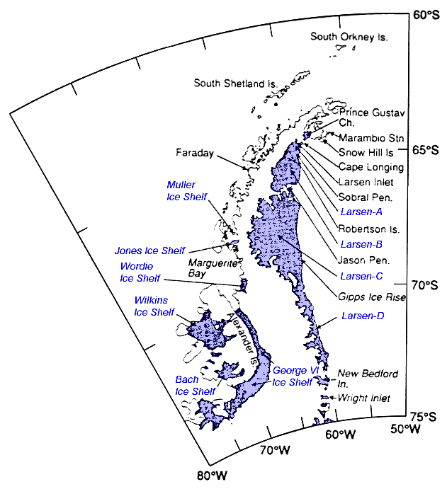 Fig. 1 - Ice shelves of the Antarctic Peninsula.
 “Ice shelves are thick plates of ice, fed by glaciers, that float on the ocean around much of Antarctica. The Larsen B [ice shelf on the Antarctic Peninsula] was about 220 meters [720 ft.] thick. Based on studies of shelf ice flow and sediment thickness beneath the ice shelf, the Larsen B is thought to have existed for at least 400 years prior to current events.
“The breakup of peninsular ice shelves has little direct consequence for sea-level rise. However the shelves act as buttresses, or braking systems, for glaciers on the continent.
'Loss of ice shelves surrounding the Antarctic continent could have a major effect on the rate of ice flow off the continent,' [glaciologist Ted] Scambos said. 'The Ross ice shelf for instance, is the main outlet for the West Antarctic Ice Sheet, which encompasses several large glaciers and contains the equivalent of 5 meters of sea level in its perched ice.'”
Information Needed To Estimate Relative Sea-Level Rise
To estimate the rise of the mean water level of the Atlantic Ocean relative to the A.R.E. Headquarters site over a given time interval requires developing credible information for the following three components of relative sea-level rise (RSLR).
- the present rate of worldwide rise in mean sea level,
- the most-probable value for future acceleration of world-wide sea-level rise, and
- the rate and direction of vertical movement of the Earth's crust underlying the A.R.E. Headquarters site.
These data can be combined to provide an estimate of relative sea-level rise over a specific time interval. One assumes here that a 20-25 year period reasonably describes the effective life of any coastal remedial measures, like sea walls, that might be used to protect coastal buildings. Also, before proceeding, note that relative sea-level rise (RSLR) varies from place to place, including as it does a site-specific value for crustal elevation changes. Values for the three components of RSLR mentioned above are estimated in the sections below.
Estimated Present Rate of Worldwide Rise in Sea Level
Changes in sea level that affect all of the world's oceans result mainly from a combination of:
- an increase or decrease in the quantity of water in the world ocean, due to melting or build-up of glacial ice masses,
- changes in the capacities of the ocean basins, due to vertical motions in sea floors, and
- changes in the volume of the ocean water molecules, due to warming. This thermal expansion component is estimated to contribute 0.6 mm/yr to global sea-level rise (SLR).
The specific effects of a, b, and c on global sea-level change are difficult to isolate.
Scientists have resorted to measuring the combined effect of the three main factors by analyzing a globally-distributed data base of 40 tide-gage records. Certain of these 40 records must be corrected for ongoing vertical crustal movements peculiar to their locations. For example, those tide gages on the U. S. east coast that are part of the 40-station network must be corrected1 for glacial-isostatic rebound (GIA). The GIA-correction process was alluded to in a 1996 article2 in the Virginian-Pilot, subtitled, "Scientists say that the mid-Atlantic coast is sinking into the ocean, with the Chesapeake Bay region going down 1-inch every 8 years." We will return to this subject later.
A careful analysis3 of global sea-level rise has settled on a value of 1.5 ± 0.3 mm/yr. This estimate is based on GIA corrections in the rate of sea-level rise found in certain of the records of the 40-tide-gage data base used for determining global sea-level rise. A few of these GIA-corrected records are from the Chesapeake Bay area.
Most-Probable Value For Future Acceleration
In The Rate of Global Sea Level Rise
Scientists believe that the greatest potential for accelerated rise in global sea level will come from climate warming and associated melting of glacial ice in the decades ahead. Note that this mechanism (factor a above) receives a great deal of coverage in the press because it has been the largest factor in sea-level change over the last 10,000 years. Also, it is relatively easy to quantify, especially as compared to factors b and c above. Concerns of accelerated climate warming, and associated melting of the Greenland and Antarctic ice sheets, have been expressed in the news media of late. Presently, the ice sheets are roughly in balance between ice input from precipitation and ice loss in the form of meltwater run-off and iceberg calving from glacier margins.4 On time scales of years to decades, precipitation changes determine the variations of ice-sheet impacts on sea-level change, with those of Antarctica apparently dominating. Precipitation variability over the ice sheets depends on far more that just atmospheric temperature changes, and thus, predicting the effects of "global warming" on global sea level is not as straight-forward as has been suggested by scientists heretofore.5
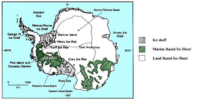
Fig. 2 - Features of Antarctica referred to in this report.
Recent atmospheric warming has resulted in the retreat of ice shelves, like the Larsen, Müller, Jones, and Wordie ice shelves (see Fig. 1) on the Antarctic Peninsula.6 (Visit the National Snow & Ice Data Center for the latest information). These ice losses, however, are not an immediate threat to coastal communities like Virginia Beach because of global sea-level rise due to their melting. The disintegration of the northern Larsen Ice Shelf (Larsen A) "did not directly influence sea level, as the ice was already floating."7 So also with the most recent disintegration of Larsen B.
But what of the on-land glacial ice upstream of the disintegrating Larsen ice shelves? Might not upstream ice move rapidly to the sea where it would raise sea-level after melting? The answer seems to be no, because "an ice sheet that was grounded on a bed below sea level might be susceptible to disintegration if the ice shelf in front of it were lost, but glaciers and ice caps on the Antarctic Peninsula, which are in large part resting on beds above sea level, should not respond radically to the [ice-shelf] loss."7
As for the Filchner-Ronnie and Ross ice shelves (Fig. 1), which may be stabilizing the vast West Antarctic Ice Sheet, these are not immediately threatened by the regional climate-warming mechanism that is destroying the ice shelves on the Antarctic Peninsula. Further warming of 10°C will be required before the -5°C mean annual isotherm -- which controls ice shelf disintegration -- will reach these ice-shelf fronts.6 This will by all accounts take several decades, at present rates of climate warming.
Finally, in 1995, the U. S. Environmental Protection Agency (EPA) completed a comprehensive report entitled "The Probability of Sea Level Rise," in which the effects of projected global warming on sea-level rise are considered.8 The EPA authors used a number of models to arrive at their global sea-level rise projections. Theirs is a very comprehensive scientific analysis. It includes a final chapter entitled, "How to use the results to project local sea level." Table 9-1 of the EPA report is reproduced immediately below. For the Virginia Beach situation that we have chosen to address -- the amount of RSLR 23 years from now -- we will go to the column headed 2025 (A.D.) and choose the value for the 50 per cent cumulative probability, or 5 cm. This is the amount of sea-level rise, to occur some 35 years from 1990, that can be attributed to climate induced acceleration in sea-level rise. The 50% probability value of 5 cm is to be added to the global sea-level rise estimate of 1.5 ± 0.3 mm/yr, mentioned earlier.
|
TABLE 1 Normalized Sea Level Projections, Compared with 1990 Levels (cm) |
||||||
| Cumulative Probability (%) |
2025 | 2050 | 2075 | 2100 | 2150 | 2200 |
| 10 | -1 | -4 | 0 | 1 | 3 | 5 |
| 20 | 1 | 3 | 6 | 10 | 16 | 23 |
| 30 | 3 | 6 | 10 | 16 | 26 | 37 |
| 40 | 4 | 8 | 14 | 20 | 35 | 51 |
| 50 | 5 | 10 | 17 | 25 | 43 | 64 |
| 60 | 6 | 13 | 21 | 30 | 53 | 78 |
| 70 | 8 | 15 | 24 | 36 | 65 | 98 |
| 80 | 9 | 18 | 29 | 44 | 80 | 125 |
| 90 | 12 | 23 | 37 | 55 | 106 | 174 |
| 95 | 14 | 27 | 43 | 66 | 134 | 231 |
| 97.5 | 17 | 31 | 50 | 78 | 167 | 296 |
| 99 | 19 | 38 | 57 | 92 | 210 | 402 |
| Mean | 5 | 11 | 18 | 27 | 51 | 81 |
| 6 | 10 | 15 | 23 | 47 | 81 | |
| NOTE: To estimate sea level at a particular location, add these estimates to the rise that would occur if current trends were to continue. For example, if sea level is currently rising 3 mm/yr, then under current trends, sea level will rise 26 cm between 1990 and 2075. Adding 26 cm to the normalized values in the Table, the median estimate for 2075 is 43 cm, with a 1 percent chance of an 83 cm rise. | ||||||
At present, some geoscientists are waving their hands about the recent rapid warming of the climate on the Antarctic Peninsula, saying that the melting there is unprecedented and bound to cause rapidly accelerating melting in the near future. They seem oblivious to the fact that there was a similar warming of the global climate in the Medieval warm period, which almost certainly affected Antarctica as well. Paul Recer, of The Associated Press (3/21/2002) reports that, “An unusually warm period a millennium ago may have been part of a natural planetary cycle, researchers say in a study of tree rings that scrutinizes the link between human activity and climate change. The study, appearing Friday in the journal Science, analyzed ancient tree rings from 14 sites on three continents in the northern hemisphere and concluded that temperatures in an era known as the Medieval Warm Period some 800 to 1,000 years ago closely matched the warming trend of the 20th century.
“In recent years, many climate scientists have said an unprecedented warming spell that began last century and continues is caused by the Greenhouse effect. The Greenhouse effect is blamed on an increase in the atmosphere of gases, principally carbon dioxide, from the burning of fossil fuels, which trap heat just as do glass panes in a greenhouse.
“The tree-ring study gives another perspective on Earth's natural cycles, said Edward Cook of the Lamont-Doherty Earth Observatory in Palisades, N.Y. Cook is co-author of the study with Jan Esper and Fritz Schweingruber of the Swiss Federal Research Institute.
“Cook said the study shows the Earth to be 'capable of rapid changes and long periods of above average warmth on its own without greenhouse warming.
'We don't use this as a refutation of greenhouse warming,' said Cook. 'But it does show that there are processes within the Earth's natural climate system that produce large changes that might be viewed as comparable to what we have seen in the 20th century.'
Cook said the study found that, based on the growth of rings in the trunks of trees that lived hundreds of years ago, the temperatures during the Medieval Warm Period were about equal to the warming trend that started in the 20th century.
'Greenhouse gases were not a factor back in the Medieval Warm Period,' said Cook.”
Estimating Vertical Crustal Movement at the Headquarters Site
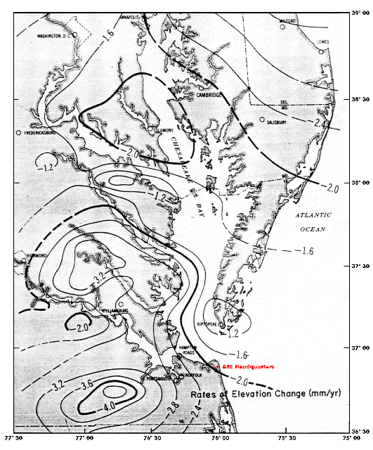 Fig. 3 - Rates of elevation change (mm/yr) in the vicinity of Chesapeake Bay. (From Figure 13 of Ref. 9.)
 The latest work on vertical crustal motion in the vicinity of the A.R.E. Headquarters is a 28-year-old study by the National Oceanographic and Atmospheric Administration's (NOAA's) S.R. Holdahl and N.L. Morrison.9 These investigators studied a) elevation changes of bench marks along re-leveled geodetic survey lines, and b) mean-water-level changes at tide gages in the Chesapeake Bay area.
As shown in Figure 3, the NOAA authors estimated that the rate of elevation change, due to crustal motion at the Headquarters site amounts to a negative 2.0 mm/yr. Their computational procedure involved a correction for global sea-level rise amounting to +1.0 mm/yr. (This is close enough to the 1.5 ± 0.3 mm/yr [reference 3] that we are using to allow us to assume that the -2.0 mm/yr due to crustal movement is suitable to use for the Headquarters site).
Thirty-Five-Year Projected Rate of
Relative Sea-Level Rise
at The A.R.E. Site
Relative sea-level rise between 1990 and 2025 may be assumed to be equal to the rate of global sea-level rise plus the rate of rise due to the slow subsidence of the crust beneath the Headquarters site plus EPA's global sea-level-rise acceleration factor. (We will use a conservative, high-end estimate of 1.53 mm/yr for ongoing global sea-level rise.) This estimated value seems appropriate in view of the very latest estimate of Douglas and Peltier10 who say that their best estimate of the rate of global sea-level rise for the past century is closer to 2 mm/yr than to 1 mm/yr.
Thus, starting from 1990 and projecting 35 years forward to 2025 A.D:
RSLR = (1.53 mm/yr) + (2.0 mm/yr) = 3.53 mm/yr,
(3.53 mm/yr) x 35 years = 124 mm, or 12.4 cm,
12.4 cm + 5.0 cm (for the EPA acceleration factor) = 17.4 cm, or 6.85 inches
[Numerical values for the main RSLR factors that we have estimated, and for the EPA acceleration factor, are shown in blue.]
But, since we are now about one-third of the way from 1990 to 2025, we can take roughly 2.05 inches off the 6.85 inches estimated for the entire 1990-2025 period. Thus, in 2025, we predict that sea level will be about 4.8 inches higher than now in the vicinity of A.R.E. Headquarters. Not much to worry about, even if our estimate is off by 50 percent.
As mentioned above, the EPA table indicates that the value of 5.0 cm that we have used for climatic acceleration of sea-level rise 35 years out has a 50 per cent probability of occurring. Because we have no data to help us estimate any acceleration or deceleration of crustal subsidence at the Headquarters site, we will assume that it will be a constant negative 2.0 mm/yr (positive 2.0 mm/yr in mean water level rise) over the 35-year period. Thus, by the year 2025, there is an even chance that the mean water level along the shore in the vicinity of the A.R.E. Headquarters may be expected to be almost five inches higher than it is today.
Wild Card Geophysical Events And Sea-Level Rise
I've been asked to speculate on possible "far-out" geophysical events that might disrupt the standard, science-based prognostications given for the magnitude and direction of sea-level rise over the next 23 years. One such speculation that comes to mind has to do with sub-glacial volcanism in Antarctica. Such a speculation would find support in the statement in 3976-15 that goes: "There will be the upheavals in the arctic and in the antarctic...." Active volcanism has recently been documented beneath the West Antarctic ice sheet, landward of the Ross Ice (Fig. 2) shelf in a "region thought to contain the inland edge of hot, actively extending lithosphere" (Blakenship, et al., 1993, Nature, v. 361, 11 Feb., p. 526.) If this volcanism suddenly were to increase, the result could be catastrophic melting of basal ice and surging of a large portion of the West Antarctic ice sheet into the sea. Melting of that ice would cause a large rise (several feet or more) in global sea level.
The other eventuality that comes to mind has to do with a sudden vertical acceleration in some of the earth's crustal plates due to mantle motions in the earth's interior. Such events could cause changes in the capacities of the ocean basins that would have a considerable effect on global sea level. There is at present no rational way to estimate such an event.
Sea Level Lowering Relative To A.R.E. Headquarters
If There is a Small Pole Shift to 89.0°N, 60.0°W
Since we have developed a calibrated model to depict land-sea boundaries immediately after a one-degree shift to 89.0°N and 60.0°W, let's look at the model output for the region offshore of Virginia Beach. In Figure 4 we see that the shore has moved out beyond the edge of the continental shelf and part way down the continental slope.
 Fig. 4 - Model output for the approximate position of the land-sea boundary in the Virginia Beach region immediately after a one-degree shift of the north pole to 89.0°N, 60.0°W. Each square is roughly five nautical miles on a side. The predicted land-sea boundary occurs between the green and blue colored areas.
 It's startling to consider that the world's greatest naval base, together with the Hampton Roads harbors and all of the other harbors of the Chesapeake Bay could suddenly be cut off by a small pole shift. But we must remember that reading 3976-15 states that “land will appear off the east coast of America.” If not off Virginia Beach, then where?
We think our modeling effort is on the right track as far as the Cayce pole-shift and Earth-changes readings are concerned. This is because we have calibrated our 1° pole-shift model to reproduce simultaneously almost all of the new land-sea relationships predicted in those readings. But regardless of what actually does unfold, we who live in the Virginia Beach area have these readings to contemplate.
Q. Is Virginia Beach to be safe?
A. It is the center - and the only seaport and center - of the White Brotherhood.... [and] .... the area where the entity is now located [Virginia Beach] will be among the safety lands, as will be portions of what is now Ohio, Indiana and Illinois, and much of the southern portion of Canada and the eastern portion of Canada; while the western lands, much of that is to be disturbed - in this land [America] - as, or course, much in other lands.
1152-11; August 13, 1941
What is The White Brotherhood?
The following note appears in the Report for reading 2067-12. It indicates that white clothing is at the explanation of the “white,” in White Brotherhood:
“Since this group [the Essenes] of mystics, prophets, healers, and miracle workers contributed so much to the origin and spread of Christianity in their making of history and the fostering of its course, it seems somewhat surprising that intelligent people know so little about this branch of the Great White Brotherhood. The Freemasons, however, find pure Christianity in Essenism and consider it to be the most important fraternity the world has ever seen. Dating back at least to the time of Moses and designated at various times and places as Nazarites, School of the Prophets, Hasidees, Nazarenes, Essenes, Therapeutae, Brethren in White Clothing....”
Reading 254-109 gives further perspective on the group itself:
Q. Were the Essenes called at various times and places Nazarites, School of the Prophets, Hasidees, Therapeutae, Nazarenes, and were they a branch of the Great White Brotherhood, starting in Egypt and taking as members Gentiles and Jews alike?
A. In general, yes. Specifically, not altogether. They were known at times as some of these; or the Nazarites were a branch or a THOUGHT of same, see? Just as in the present one would say that any denomination by name is a branch of the Christian-Protestant faith, see? So were those of the various groups, though their purpose was of the first foundations of the prophets as established, or as understood from the school of prophets, by Elijah; and propagated and studied through the things begun by Samuel. The movement was NOT an Egyptian one, though ADOPTED by those in another period - or an earlier period - and made a part of the whole movement. They took Jews and Gentiles alike as members, - yes.
Finally, on a more personal, and contemporary note, we find in reading 254-83:
Q. To what extent are the Masters of the Great White Brotherhood directing the activities of Edgar Cayce? Who are the Masters directly in charge?
A. MESSENGERS from the higher forces that may manifest from the Throne of Grace itself.
Q. Who are the Masters directly in charge? Is Saint Germain - [Comte de (c. 1710 c. 1780)?] -
A. (interrupting) Those that are directed by the Lord of lords, the King of kings, Him that came that ye might be one with the Father.
Q. Is Saint Germain among them? Who is Halaliel?
A. These are all but messengers of the Most High. Halaliel is the one who from the beginning has been a leader of the heavenly host, who has defied Ariel, who has made the ways that have been heavy - but as the means for the UNDERSTANDING. [Isaiah 29th chapter?]
Q. Is Saint-Germain among them? [GD's note: I understand the Ballard I AM movement was based on Saint-Germain.]
A. When needed.
Q. Please give us Thine Identity?
A. He that seeks that has not gained control seeks damnation to his own soul! Control thine inner self that YE may KNOW the true life and light! For he that would name the Name must have become perfect in himself!
Q. If Mr. Cayce is a member and a messenger of the Great White Brotherhood, how do the Masters wish him to proceed and should not his activities henceforth be presented as Their Work?
A. As the work of the MASTER of masters, that may be presented when in those lines, those accords necessary through the White Brotherhood. This - this - THIS, my friends, even but LIMITS; while in Him is the Whole. Would thou make of thyself, of thyselves, a limited means of activity? Would thou seek to be hindered by those things that have made of many contending forces that continue to war one with another even in the air, even in the elemental forces? For He, thy Lord, thy God, hath called thee by name, even as He has given, "Whosoever will drink the cup, even as of my blood, he may indeed be free." While ye labor, let HIM that is the author, that is the finisher, that IS the Life, that is the bread of life, that is the blood of life, let HIM alone be thy guide! Dost He call any soul into service, THEN by name will He - does He - designate, and to whom it becomes a charge to keep - even as he has walked with Him, this body that ye use as a channel of approach to the Throne; ye make of same oft as a laughingstock to thy very soul through thine own selfishness! Let the light of Him, thy Christ, thy God, IN, that it may cleanse thy body, that it may lighten thy soul, that it may purge thy mind, that ye will only be just gentle, just kind; not find fault with any, for with faults ye build BARRIERS to thine own soul's enlightenment. "I, thy God, thy Christ, beseech thee!"
In the reading above, the Halaliel mentioned is the same archangel who spoke through Cayce during reading 3976-15, on January 19, 1934, saying, “Land will appear off the east coast of America.” And with respect to Virginia Beach being “the only seaport and center” of the White Brotherhood,one possible interpretation is that there may be other centers. One could be the Ascended Master Teaching Foundation at Mount Shasta, CA 96067., founded by Guy W. Ballard, mentioned in 254-83 above. Reading 957-1 may be supportive of this speculation.
Q. What organizations, or what channels should I use to do my cosmic work; and to give out the Spiritual light that can be reflected through me?
A. Through that of the [White?] brotherhood as is established in the mount (for the entity has approach to the Holy Mount) [Mount Shasta?-Hutton's speculation]; also among those associated in the school [Atlantic University?], wherein the expressions were given, "That Man May Make Manifest HIS Love For God And Man."
At this point in trying to understand what reading 1152-11 means relative to the White Brotherhood, I contacted one of THC's subscribers who has studied the works of the I AM movement for several years. This movement speaks often of the Great White Brotherhood. I asked him what he thought about reading 957-1, with special reference to the “the mount.” Might it refer to Mount Shasta? His answer seems somewhat more satisfactory than my speculation. See if you don't agree.
Our subscriber begins by citing the following reading (262-36):
Remember the pattern in the mount, in self, in the physical body, in the mental body, in the spiritual body. THAT is the mount! So long as there is perfect coordination in the mount, all things work together for the GOOD of the mount.
When there is the rebellion in the mount, then there is disconnection, destruction, disconcerted effort, and the coordination - the cooperation of activity - is made awry.
Hence death in the physical ensues, by the disintegration.
He then says:
“I believe that reading 957-1 is telling Mr. 957 to use the approach of The Great White Brotherhood to master self; that is, to develop the self through that which the Great White Brotherhood Teaches and works. That teaching is to yield to the Almighty and let the God self within take the bodies of oneself under control until the individual is a replica of God walking on the Earth. The Earth was created to be a school for teaching souls certain aspects of Self-growth. After the "Fall of Man" the Earth became corrupted from its purpose but, using the methods taught by the Great White Brotherhood, it provides the way home. In this way, men and women may make manifest HIS love for God and mankind.
“Personally, I thank God for Edgar Cayce and for the readings given through him. For me, at least, the readings have been stepping stones to what I have come to believe are higher teachings -- those of the Great White Brotherhood of whom Jesus and St. Germain are members.”
[Note: One can find out more about The Great White Brotherhood by writing to The Ascended Master Teaching Foundation, P.O. Box 466, Mount Shasta, CA 96067].
- Mitrovica, J.X., and J. L. Davis, 1995, Present-day post-glacial sea level change far from the Late Pleistocene ice sheets: Implications for recent analyses of tide gauge records, Geophys. Res. Letters, v. 22, no. 18, p. 2259-2532, Sept. 15.
- Virginian Pilot, January 25, 1996.
- J. L. Davis and J. X. Mitrovica, 1996, Glacial isostatic adjustment and the anomalous tide gauge record of eastern North America, Nature, v. 379, January 25, p. 331-333.
- Bromwich D., 1995, Ice sheets and sea level, Nature, v. 373, January 5, p. 18-19.
- Warrick, R., and J. Oerlemans, 1990, Climate change: The IPCC Scientific Assessment, p. 257-281, Cambridge Univ. Press.
- Vaughan, D. G., and C.S.M. Doake, 1996, Recent atmospheric warming and retreat of ice shelves on the Antarctic Peninsula, Nature, v. 379, Jan. 25, p. 328-330.
- Fahnestock, M., 1996, An ice shelf breakup, Science, v. 271, p 775-776.
- Titus, J. G., and V. K. Narayanan, 1995, The probability of sea level rise, U.S. Env. Protect. Agency Rept. 230-R-95-008, Oct., 186 p.
- Holdahl, S. R., and N. L. Morrison, 1974, Regional investigations of vertical crustal movements in the U. S., using precise relevelings and mareograph data, Tectonophysics, v. 23, p. 373-390.
- Douglas, B. C., and W. R. Peltier, 2002, The puzzle of global sea-level rise: Physics Today, March 2002, p. 35-40.