
Archived Articles
Are “Many Various Minerals” Present
At Shallow Depth Beneath Bimini?
At Shallow Depth Beneath Bimini?
Testing The Validity of Edgar Cayce Reading 996-12
Part 1
By William Hutton and Jonathan Eagle
Background
The legacy organization of American psychic, Edgar Cayce (died 1945), is called The Association for Research and Enlightenment, Inc. The A.R.E. has been promoting an “Atlantis Search” in the Bahamas for the last several years. In connection with this search, a few submersible dives were made off Bimini in the Gulf Stream in 1998 and 1999 (D. Richards, 2003)1, during which incidental observations of rocks were made. The predominent search effort by A.R.E. and others has mostly involved SCUBA diving observations of sea-floor rocks or sediment patterns in the offshore waters of the Andros and Bimini Islands. The features observed, however, are far too young to have relevance to the 10,000 BC date given in Cayce's readings for the final destruction of Atlantis. And the exploration guidance provided in his readings has largely been ignored.
For example, two extracts from one of Cayce's readings in the Atlantis series, provide the following guidance:
…while the destruction of this {Atlantean} continent and the peoples are far beyond any of that as has been kept as an absolute record, that record in the rocks still remains….{emphasis added by authors}
The position as the continent Atlantis occupied, is that as between the Gulf of Mexico on the one hand - and the Mediterranean upon the other. Evidences of this lost civilization are to be found in the Pyrenees and Morocco on the one hand, British Honduras, Yucatan and America upon the other. There are some protruding portions within this that must have at one time or another been a portion of this great continent. The British West Indies or the Bahamas, and a portion of same that may be seen in the present - if the geological survey would be made in some of these - especially, or notably, in Bimini and in the Gulf Stream through this vicinity, these may be even yet determined.*
364-3; February 16, 1932
* Note that in all of the readings cited in this article words set in bold are for authors' emphasis. Words set in curly brackets '{}' are authors' interpretations, and words set in parentheses '()' or square braces '[]' represent stenographer-attempted clarifications of perplexing words channeled by Cayce during a reading.
Because Hutton is a geologist with 45 years intermittent research experience at Bimini, and because Eagle has been involved with those who have sought and failed to find evidence of Atlantis in surficial bottom materials, or in islands in the Bimini lagoon and nearshore environments, we decided to do our own “geological survey ... in Bimini,” as recommended in the reading above.
Our current geological efforts at Bimini began with our inspection of satellite images being used by Eagle to interpret the natural features of the Bimini area. These IKONOS satellite images were obtained in 2001 from Space Imaging, Inc. in response to an order placed by Eagle. It was clear from the imagery that a new boat channel over a mile in length had been cut into the Bimini lagoon from north Bailey Town to Bimini Bay (Fig 2). In April 2002, we visited Bimini to examine the dredgate being pulled up by the power shovels that were doing the actual dredging. Results from our sampling trip indicated nothing unusual about the rocks examined. It is possible that because the channel was dredged to only 15 ft below mean low water (MLW), the channel did not actually intersect the presumed mineralized vein at any point. We then decided to conduct a marine magnetic survey (see Appendix) and a geochemical trace-element survey to further ascertain whether there was any validity to the statements in readings 364-3 and 996-12 above.
Probing the Fourth Dimension at Bimini
If latitude, longitude, and altitude are the three dimensions describing the geomorphology of Bimini, then the natural history of Bimini is its fourth dimension. To usefully probe what was happening in that dimension one needs to know the relative positions of land-sea boundaries in the Bahamas area over the last 11,000 to 12,000 years, or more. Reading 288-1 states that the last island of Atlantis, Poseidia, sank beneath the sea around 11,900 years before the present (BP).
Land-sea boundaries are important to the interpretations of statements in Cayce's readings on Bimini and to estimate the age of any exotic subsurface artifacts or rocks that may be found there.
The best curve of sea-level rise for the general Bahamas region is the one constructed by M. Toscano and I. Macintyre (2003, Fig. 5)2 which we have simplified and inserted here as our Figure 1. This curve allows one to deal precisely with the time factor in explorations at Bimini. The 14C dates that comprise this curve have all been re-calculated from the original 14C “dates” to calendar years (real years), making them meaningful when compared to other forms of absolute dating and historical markers. We used this curve in the present study to assign approximate ages to the samples of marine sediments and submerged rocks that we sampled.
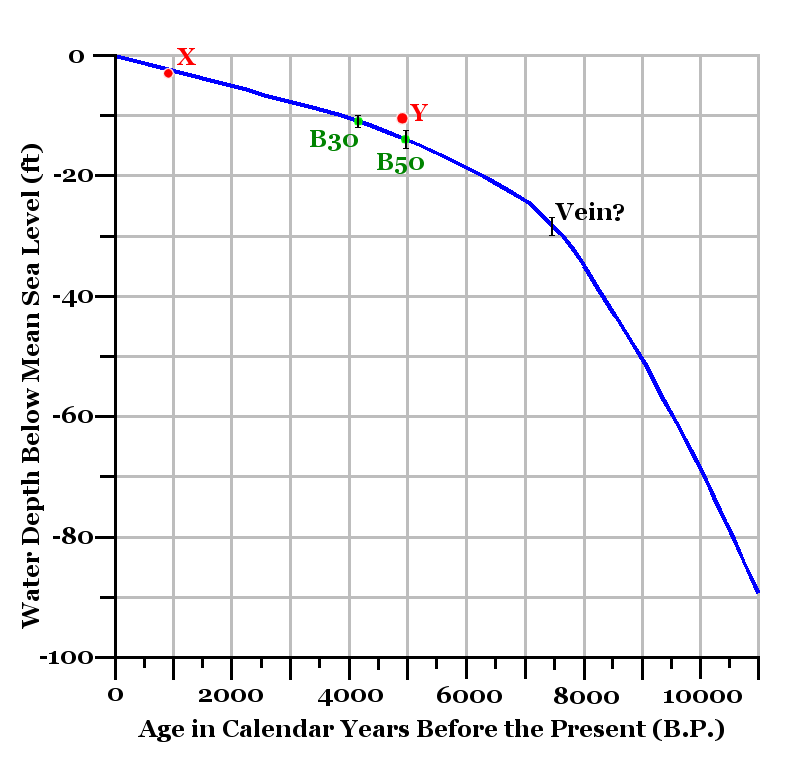
Fig. 1 - This curve of relative sea-level rise reflects a reasonable demarcation between intertidal peat data (maximum sea-level) and shallow reef crest A. palmata data (minimum sea level required to submerge coral). The sea-level rise curve was constructed by Toscano and Macintyre (2003) who wrote as follows. “All {rates of sea-level rise} are well below the maximum accretion rate of A. palmata and are not indicative of extreme pulses capable of effecting reef drowning and subsequent backstepping."
The two values plotted and shown in red (labeled X and Y) are from peat samples taken at Bimini. Their original 14C dates have been corrected to calendar years B.P. Sample X was an intertidal peat cored 560 ft north of North Point on North Bimini, at about 3.0 ft below MSL, in February 1972 (Teledyne Isotopes Corp. No. I 6456). Sample Y (L-366B) was a "mangrove peat" core taken 9 ft below MLW (W. Broecker and J. Kulp, 1957, Science, v. 126, p. 1,328). Elevations of both samples relative to mean sea level have been estimated and the calendar ages are: X = 918 years (elev. -3.0 ft MSL) and Y = 4,944 years (elev. -10.5 ft MSL). 3
The approximate ages of samples B30 (4,100 B.P.), B50 (5,000 B.P.), and the time of submergence of the mineralized vein (7,500 B.P.) are inferred from their respective positions relative to this curve of sea-level rise. See discussion later in the text.
Cayce's Reading 996-12, About Resort Development on Bimini
Mr. Cayce gave several readings in 1926 and 1927 for investors desirous of finding buried treasure, or in developing a resort, on the islands of North and South Bimini. These Bahamian islands are located about 55 miles east of Miami, Florida, on the eastern side of the Gulf Stream.
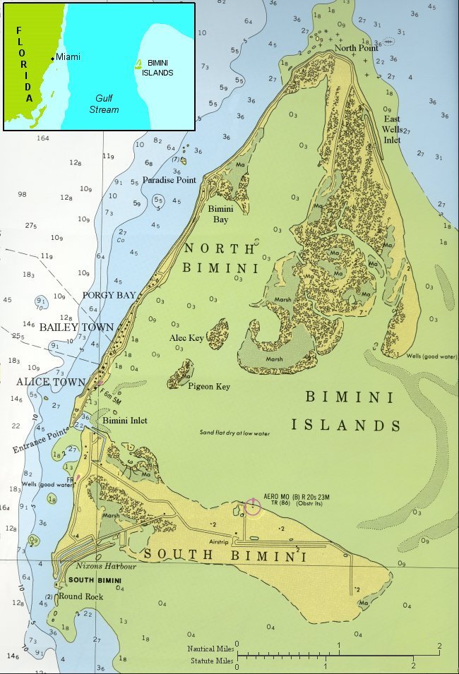 Fig. 2 - The Bimini Islands, as modified from Chart 38B issued by the International Sailing Supply. (The unmodified version can be purchased from Waterproof Charts, Inc.) Water depths are shown in meters.
 In 996-12, the last surviving reading of a series of 13, one reads these fragments:
Now, we find there are many things that may be said as respecting the plausibility and the advisability of making a resort city in this location. First we would give, this would not be near as large an undertaking as it appears on the face of conditions, for this may be stored away as truth for those that would go about to accomplish such conditions: There will be found many, many, MANY sources of revenue for those undertaking such a project, for these mountain tops – especially that along the north and eastern shores of the north and northern portion of the south island – will produce many various minerals, and various other conditions that will be remunerative when the projects are undertaken; and well that the ones that do such labors – as the dredging as necessary, the building as necessary, the walls, etc. – be followed close in their operations, for these will uncover many various conditions that may be turned into dollars – and dollars – and dollars!
(Q) Is this the continent known as Alta or Poseidia? [Atlantis]
(A) A temple of the Poseidians was in a portion of this land.
(Q) What minerals will be found here?
(A) Gold, spar, and icthyolite [?]. [Ichthyolite?]
(Q) How deep in the ground will that be found?
(A) In the wall that would be builded from the western portion of the south island towards that of the PROMINENT portions of the southern portion of isle – these will be found in the twelve to fifteen (12 to 15) foot levels. The VEIN, as workable, would be found extending in the northeast-southwest direction. The waters in the northern portion of the south island. Sweet water, see?
(Q) Give the exact longitude and latitude of the vein?
(A) In this we have the island – in this we have the place. Find these, or locate. These are known.
996-12; March 2, 1927
Now the northwestern Great Bahama Bank is thought by most geoscientists to consist entirely of carbonate sediment and coralline limestone thousands of feet thick. Thus, the very idea of finding a mineralized zone in rocks near the surface of a 17,000-ft-thick pile of carbonate rock beneath Bimini seems preposterous. But the moving line between the imaginary and the real is present not only in journalistic endeavors but also in geologic conjectures, as many an exploration geologist can affirm.
The authors have discussed their search for a mineralized zone on Bimini in their recent book, Earth's Catastrophic Past and Future.4 Hutton has been interested in this subject since 1961 when he published a note in a booklet entitled, Earth Changes, Past – Present – Future.5 Figure 3, copied from the section of that booklet entitled “Atlantis at Bimini?” shows Hutton's initial concept of the locations of the wall and vein mentioned in the reading above.
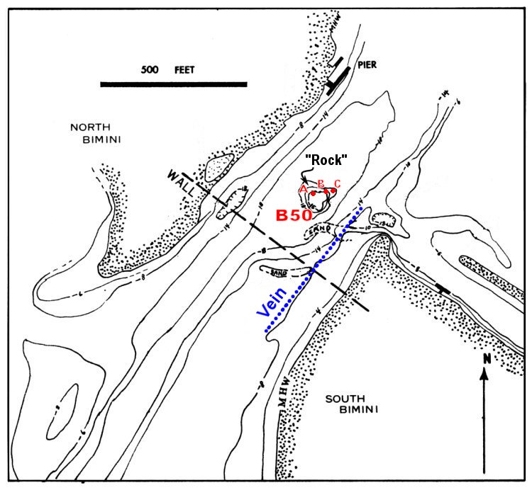 Fig. 3 - Potential location of a “wall,” to act as a dam for hydroelectric power generation at the tidal inlet between North and South Bimini. Possible trend of hypothetical mineralized vein is also shown in blue. Bathymetric contours are in feet below mean high water. Sample station B50, for the geochemical survey described later, is shown here to illustrate the spatial relation of samples B50A, B, and C as well as their proximity to thevein inferred by Hutton in 1961.
 In a later (1996) book, Coming Earth Changes6, Hutton elaborated on other readings dealing with Atlantis and Bimini.
The following Cayce reading says that records of the construction of an Atlantean power station may be found in the sunken portion of Poseidia where "a portion of the {Atlantean} temples may yet be discovered under the slime of ages of sea water… {a location that we believe to be near the Azores}....and that the center of the original power station {was lined with}.... something akin to asbestos, with the combined forces of bakelite or other nonconductors...."
Q) Give an account of the electrical and mechanical knowledge of the entity as Asal-Sine in Atlantis.
A) Yes, we have the entity's activities during that experience. As indicated, the entity was associated with those that dealt with the mechanical appliances and their application during the experience. And, as we find, it was a period when there was much that has not even been thought of as yet in the present experiences.
About the firestone that was in the experience did the activities of the entity then make those applications that dealt with both the constructive and destructive forces in the period.
It would be well that there be given something of a description of this, as to how both constructive and destructive forces were generated by the activity of this stone.
In the center of a building, that today would be said to have been lined with non-conductive metals, or non-conductive stone - something akin to bakerite [bakelite?] or other non-conductors that are now being manufactured in England under a name that is known well to many of those that deal in such things.
The building above the stone was oval, or a dome wherein there could be or was the rolling back, so that the activity of the stone was received from the sun's rays, or from the stars; the concentrating of the energies that emanate from bodies that are on fire themselves - with the elements that are found and are not found in the Earth's atmosphere. The concentration through the prisms or glass, as would be called in the present, was in such a manner that it acted upon the instruments that were connected with the various modes of travel, through induction methods - that made much the character of control as the remote control through radio vibrations or directions would be in the present day; through the manner of the force that was impelled from the stone acted upon the motivating forces in the crafts themselves.
There was the preparation so that when the dome was rolled back there might be little or no hindrance in the application. We find it was a large cylindrical glass (as would be termed today), cut with facets in such a manner that the capstone on top of same made for the centralizing of the power or force that concentrated between the end of the cylinder and the capstone itself.
As indicated, the records of the manners of construction of same are in three places in the Earth, as it stands today: {1} In the sunken portions of Atlantis, or Poseidia, where a portion of the temples may yet be discovered, under the slime of ages of sea water – {2} near what is known as Bimini, off the coast of Florida. And {3} in the temple records that were in Egypt, where the entity later acted in cooperation with others in preserving the records that came from the land where these had been kept. Also the records that were carried [by Iltar?] to what is now Yucatan in America, where these stones (that they know so little about) are now – during the last few months – BEING uncovered.
440-5, December 20, 1933
{Note that the numbers in brackets have been added by the authors. Others may interpret the sentence structure of this paragraph differently. But Hutton, who had many meetings with Gladys Davis, Cayce's stenographer for the 996-series of readings, once asked Gladys about whether she was told in any given reading how to punctuate complicated sentences dictated by Cayce. She said that most of the time, punctuation was left to her, and that she just did her best when typing up a reading. But, she said, one should not conclude that an alternate punctuation might not be correct.}
At any rate, the authors think that Yucatan in the above reading was a fourth location that held simple representations of the crystal ("the stones"), but not the complete construction specifications. The use of the word “also” at the beginning of the last sentence in reading 440-5 above seems to support this surmise. Our interpretation is also bolstered by reading 2012-1 for a young physicist who was told that he was involved in preserving the “records of the activities of individuals”, rather than specific technological records. One of the places that was said to hold these more general Atlantean historical records was in the Yucatan. Bimini was not mentioned 2012-1 as a repository of these more general records, but “the records of the manners of construction” were mentioned in 440-5 as being “near what is known as Bimini.”
Consider this reading also.
.... {men on Atlantis} brought in the destructive forces as used for the peoples that were to be the rule, that combined with those natural resources of the gases, of the electrical forces, made in nature and natural form the first of the eruptions that awoke from the depth of the slow cooling Earth, and that portion {of Atlantis} now near what would be termed the Sargasso Sea first went into the depths.
364-4; February 19, 1932
As mentioned earlier, the extremely catastrophic event described in the reading immediately above probably occurred 19,400 years ago (reading 364-11). It did not occur 11,900 years ago, when the last of the Atlantean islands sank, but two readings indicate that there was a sort of repeat of the type of destruction described for 19,400 B.P., one occurring between 12,700 and 11,900 B.P.
....in those latter periods, 10,700 years before the Prince of Peace came -- again was the bringing into forces that to TEMPT, as it were, nature -- in its storehouse -- of replenishing the things -- that of the WASTING away in the mountains, then into the valleys, then into the sea itself, and the disintegration of the lands, as well as of the peoples -- save those that had escaped into those distant lands.
364-4; February 16, 1932
Again we find the entity {Gladys Davis} in that sex as given, and was in the household of the ruler of that country {Poseidia}. (This body, not physically, will be present when the Earth is changed again, see?) This we find nearly 10,000 years before the Prince of Peace came, and this entity then found the destructive forces to life in the misapprehension of those who were attempting to be of assistance, and not by their fault was the catastrophe brought.....
288-1, November 20, 1923
Plan For Testing The Validity of Cayce Reading 996-12
The authors decided to search for the presence of the supposed mineralized vein described in reading 996-12 using indirect exploration techniques. This involved three steps.
- Eagle constructed a satellite map of the Bimini Islands.7 This permitted us to plot precisely the locations of sampling sites and future survey lines.
- Hutton and Eagle designed and conducted a magnetic survey (see Appendix) of the inlet and surrounding land area of interest to try to locate the northeast-southwest trending mineralized vein.
- Hutton and Eagle designed and conducted a geochemical survey to see if the presence or absence of specific metal ions could be detected along any magnetic trend observed in step two.
Marine magnetic survey. Sometime around 1970, H. Jensen of Aero Services Corporation gave Hutton a copy of an aeromagnetic map of the Bimini Islands area. The map appeared to be a residual magnetic field map; that is, a map of total magnetic intensity with the regional field subtracted. This map prompted Hutton to start thinking about the possibility of some sort of buried volcanic terrain lying beneath the surface of the northwestern Great Bahama Bank. The magnetic low (less than 6070 gamma) in the vicinity of the Bimini inlet was particularly interesting. It suggested a volcano vent filled with lava of weaker magnetic susceptibility than the surrounding material, hence the magnetic low in the residual magnetic field strength of Figure 4.
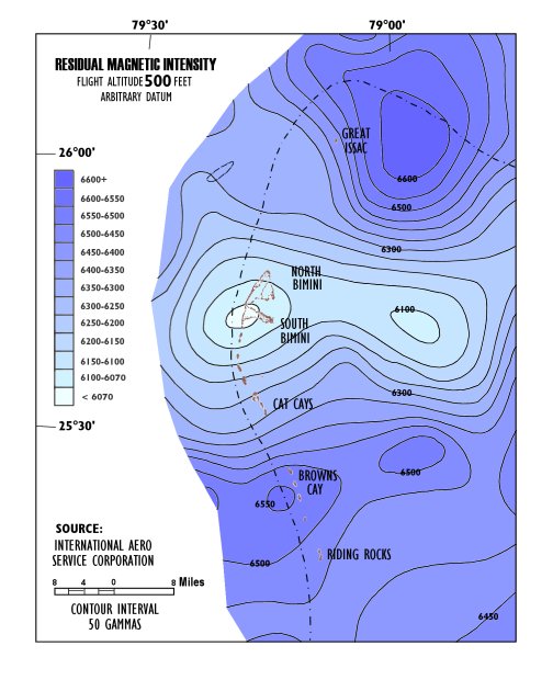 Fig 4. Residual aeromagnetic map of the Bimini area, northwestern Great Bahama Bank. (1 gamma = 1 nanoTesla)
 Details of our 2004 magnetic survey are given in chapter 29 of our book,8 Earth's Catastrophic Past and Future. Figure 3 of chapter 29 shows the results of our work, in the form of a magnetic map of the inlet area. It is reproduced here as Figure 5.
As a result of these speculations, Hutton made a further conjecture. He suggested that there might be an unusual type of volcanic rock beneath Bimini, to account for the many varied minerals predicted in 996-12 to exist there at a shallow depth of 12-15 ft. And only a thin layer of carbonate rock in the vicinity of the Bimini inlet might cover the conjectured volcanic rock. Or, the regional residual magnetic map of Figure 4 could be representing the relatively less magnetic igneous-rock core of a carbonatite volcano.
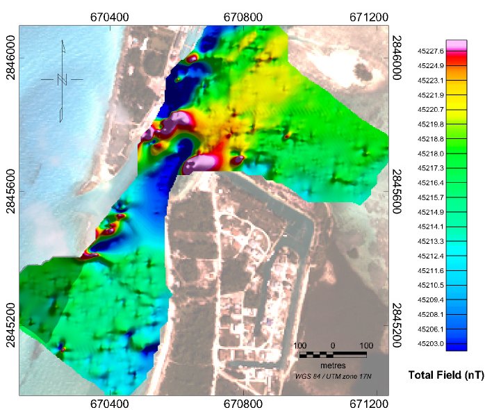 Fig. 5. Total field magnetic map for the inlet area. The change in magnetic intensity across the survey area is about 25 nT. Areas of high magnetic intensity (darkest red and pink) at NW end of inlet are possibly due to ferrous (iron) targets or perhaps outcrops of the mineralized vein. Several smaller ferro-metallic iron targets may also be indicated by localized magnetic highs. We interpret the northeast-southwest trending yellow zone to be the signature of the buried mineralized vein.
 Note the northeast-southwest trending yellow pattern along the eastern side of the inlet channel. This is interpreted to reflect the mineralized zone of reading 996-12. The magnetic trend extends to the southwest. It then runs beneath the northwestern point of South Bimini. We explained the hypothetical mineralized zone as being a weakly-magnetic body with just enough iron-rich hematite (Fe2O3), or other iron material, to allow distinction of the mineralized vein from the surrounding, relatively more iron-poor, carbonate sedimentary rock.
In chapter 28 of our book, Hutton speculated that the potential mineralized zone could reside in the peak of a buried volcano, one composed of natrocarbonatite lava. One such modern volcano is Ol Doinyo, in the Gregory Rift Valley of Africa. It is intermittently active today. While uncommon in the geologic record, this type of volcano often contains ijolite rocks that display many varied minerals containing trace elements like yttrium, zirconium, niobium, lanthanum, and cerium.
Hutton also speculated that instead of a buried volcanic peak beneath Bimini, there might be a lava dike that intruded into a fault extending upward from the basement volcanic rocks almost to the present surface. Such a weakly magnetic carbonatite exudation could have risen to the Pleistocene-age land surface around the time of the first destruction of Atlantis in 19,400 B.P., when massive destruction caused a major portion of the island subcontinent to split up and sink near the Sargasso Sea.
A third explanation of the magnetic trend in Figure 5 could be considered also. The magnetic lineation could simply be due to fly ash having been deposited in the days when steamships, powered by coal-fired boilers, visited the Bimini harbor. This could be detected by analyzing for iron in the sediments sampled in our geochemical survey.
In Part 2 of this article we explore the use of Mobile Metal Ion (MMI) analysis to to detect the presence of metal mineralizations embedded in the calcium carbonate layers covering the hypothesized mineralized vein predicted by the Edgar Cayce readings.
- Richards, D., "The Search for Atlantis in Bimini," Chapter 3 in Little, G. and L. Little, 2003, The A.R.E.'s Search For Atlantis - The Ongoing Search for Edgar Cayce's Atlantis in the Bahamas, Eagle Wing Books, Memphis, TN, pp. 244
- Toscano, M.A., and I. G. Macintyre, 2003, Corrected western Atlantic sea-level curve for the last 11,000 years based on calibrated 14C dates from Acropora framework and intertidal mangrove peat, Coral Reefs, 22: pp. 257-270.
- The original “old” dates were first converted to "conventional" radiocarbon dates by correcting for δ 13C fractionation and then calibrating the corrected dates. Correcting for δ 13C required using an estimate for mangroves of –27 ± 0.2 ‰ to get the radiocarbon age. Then, the CALIB radiocarbon calibration program of M. Stuiver and P. Reimer was used (M. Stuiver, and P. Reimer, 1993, Radiocarbon, v. 35, pp. 215-230. The calibration data set, intcal104.14c, was also used (P. Reimer, et al., 2004, Radiocarbon, v. 46, pp. 1029-1058).
- Hutton, W., and J. Eagle, 2004, Earth's Catastrophic Past and Future – A scientific analysis of information channeled by Edgar Cayce, Universal Publishers, Boca Raton, FL, 372 pp. (See chapters 28 and 29).
- Anonymous, 1961, Earth Changes, Past – Present – Future, A.R.E. Press, Virginia Beach, VA 23451, 80 pp.
- Hutton, W., 1996, Coming Earth Changes, Causes and consequences of the approaching pole shift – Edgar Cayce's psychic predictions and the latest evidence, A.R.E. Press, Virginia Beach, VA 23451, 341 pp.
- Eagle, J., 2001, Results Of Satellite Remote-Sensing On The Northwest Grand Bahama Bank, report submitted to Association for Research and Enlightenment, 215 67th Street, Virginia Beach, Virginia 23451.
- Hutton, W., and J. Eagle, 2004, Earth's Catastrophic Past and Future – A scientific analysis of information channeled by Edgar Cayce, Universal Publishers, Boca Raton, FL, 372 pp. (See chapters 28 and 29).
Page Created: July 24, 2005 Last Updated: July 24, 2006